Plan of the Bar and Entrance of Bancoot river on the...


 Maps, plans and nautical charts
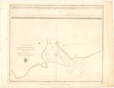
Plan of the Bar and Entrance of Bancoot river on the Malabar Coast : Fort Victoria Lat. 17°.58'N. Long. 0°.12'E.... (1789)
Maps, plans and nautical charts
Plan of the Bar and Entrance of Bancoot river on the Malabar Coast : Fort Victoria Lat. 17°.58'N. Long. 0°.12'E.... (1789)
 Disponible Holdings
 Section: Maps, plans and nautical charts
Uniform title: India. Cartas náuticas. 1789. 1:23000 (1787 1789)
Title: Plan of the Bar and Entrance of Bancoot river on the Malabar Coast : Fort Victoria Lat. 17°.58'N. Long. 0°.12'E. from Bombay / by John M. Cluer
Material or type of resouce Area: Escala [ca. 1:23000], 4 nautic miles [= 32,2 cm]
Publication: [London ?] : Published according to Act of Parliament by A Dalrymple Novr. 27th..., 1789
Physical description: 1 carta náutica ; 33,1x42,4 cm
Content type: Imagen cartográfica
Media type: computadora
Carrier type: recurso en línea
Notes: Presenta además 1 vista
Orientado con lis en nudo de rumbos
Relieve representado por sondas batimétricas en piés
Indica veriles, bajos y fondeaderos
Sello de la Hydrographical Office
Materia / lugar / evento: Cartas náuticas
Ríos
Costas
1787
Bancoot (Río)
Other authors: McCluer, John
Walker, James
Harrison, W
UDC: 912:[551.46:556.53](540-15)'1787-1789'
540-15
Type of publication:
Maps
Rights:
Préstamo:
Disponible
