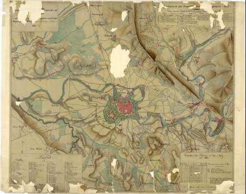
Plan de Pampelune et sus environs et les operations du siege


 Disponible Holdings
 Section: Maps, plans and nautical charts
Uniform title: Pamplona. Estrategia militar (1825). 1:15.000
Title: Plan de Pampelune et sus environs et les operations du siege / Levé [...] Capitaine au 9e deligue Dessine par [Vendel] Neuma [...] Capitaine de Granaderes au 6° de Luque 1825
Material or type of resouce Area: Escala 1:15000
Physical description: 1 mapa : ms., col., papel vegetal ; 65 x77
Content type: Imagen cartográfica
Media type: computadora
Carrier type: recurso en línea
Notes: Comprende parte de los partidos judiciales de Pamplona y Aoíz en la provincia de Navarra
Mención de responsabilidad tomada del catálogo del SGE: "Región Vasco-Navarra. Provincia de Navarra. Siglos XVII a XIX". 1969, p. 360
Escala también dada en forma gráfica, de 1100 metros. Orientado con flecha
Orografía por curvas de configuración croquisadas sin cotas y normales
Relación de las posiciones ocupadas por las tropas pertenecientes a distintos cuerpos y divisiones del ejército el 3 de septiembre de 1823, indicadas por clave numérica, señalándose en el plano los movimientos ejecutados por las mismas
Relación de la situación de las baterías, durante el bloqueo de la ciudad, en la misma fecha, indicadas por clave numérica
Relación de todas las dependencias de la ciudad fortificada de Pamplona y de los edificios, calles y plazas, fuertes, conventos, etc., más destacados de la ciudad, indicados por clave numérica
Iluminado en siena, verde, carmín, azul
Materia / lugar / evento: Estrategia militar
Planos de población
Mapas topográficos
Operaciones bélicas
Fortificaciones
1825
Aoiz
Navarra (Comunidad Autónoma)
Pamplona
UDC: 912:355.43:355.4+[314(084.3)]:623.1(465.111.1)(465.111.3)"1823"
465.111.1
465.111.3
465.111.3-2
Type of publication:
 Maps
Maps
Rights:
Préstamo:
Disponible
