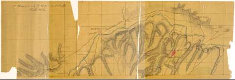
Partie du Cours du Tage et environs


Section: Maps, plans and nautical charts
Title: Partie du Cours du Tage et environs / [Depósito de la Guerra]
Material or type of resouce Area: Escala 1:50000
Physical description: 1 mapa en 2 hoja : ms., col., papel vegetal ; en hoja de 59,9 x 92,3 cm o menor
Content type: Imagen cartográfica
Media type: computadora
Carrier type: recurso en línea
Notes: Comprende parte de los partidos judiciales de Toledo, Talavera de la Reina, Torrijos y Ocaña, en la provincia de Toledo pasando, entre otros, por los términos municipales de Cebolla, La Puebla de Montalbán, Polan, Yepes, Nambroca, en la provincia de Toledo
Orografía por sombreado, curvas de configuración y normales
En el margen inferior: "17l Nos. 94a (1186) 4-4-B-N°758", "17l Nos. 94b (1187-18) 4-4-B-N°759" y "Recibido el 15 octubre de 1858 - Costo 65 francos". "Recibido el 15 Octubre 1858 - Costó 230 francos"
El mapa original fue realizado en 1823 por oficiales franceses pertenecientes al ejército de los "Cien Mil hijos de San Luis" y la presente copia en 1858 en el Depósito de la Guerra, por orden de D. Francisco Coello, según consta en el catálogo del SGE: "Castilla la Nueva. Provincias de Toledo, Ciudad Real, Cuenca y Guadalajara. Siglos XVII a XIX, p. 175
Relacionado con los documentos de sign. SGE-Ar.E-T.8-C.4-175(1 al 5 y 7)
Iluminado en siena, carmín, azul y verde
Materia / lugar / evento: Mapas generales
Ríos
1858
Toledo (Provincia)
Torrijos
Tajo (Río)
Ocaña
Castilla-La Mancha
Other authors: España. Depósito de la Guerra
UDC: 912(464.221/.223)(464.217)(464.2:282.246.23)"1858"
464.221
464.222
464.223
464.217
464.2:282.246.23
Type of publication:
 Maps
Maps
Rights:
Préstamo:
 Disponible
