Palma, Gomera and Hierro or Ferro


Section: Maps, plans and nautical charts
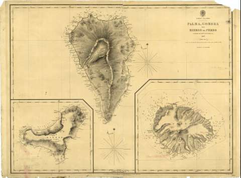
Title: Palma, Gomera and Hierro or Ferro / surveyed by captn. A.T.E. Vidal R.N. ; J & C. Walker Sculpt.
Material or type of resouce Area: Escala [ca. 1:150000] ; proyec. Mercator (O18°10'-17°20'/N28°50'-N27°40)
Publication: London : ... at the Hydrographic office of the Admiralty, 1848
Physical description: 1 mapa ; 50,5x68,2 cm
Content type: Imagen cartográfica
Media type: computadora
Carrier type: recurso en línea
Notes: Escala hallada a partir de 5' de latitud [= 6,2 cm]. Hay un error en los grados de la latitud. Orientado con estrella en nudo de 32 vientos. Indica el ángulo de declinación magnética
Relieve representado por normales y puntos acotados
Indica bajos y sondas batimétricas
Clave hidrográfica para determinar la calidad del fondo
Sello del Hydrographic Office
Anotaciones manuscritas de Francisco de Coello
Incluye un plano de la Isla de la Gomera y otro de la Isla de Hierro
Materia / lugar / evento: Cartas náuticas
1848
1837
Santa Cruz de Tenerife (Provincia)
El Hierro (Isla)
La Palma
La Gomera
Canarias
España
Other authors: Vidal, Alexander Thomas Emeric
Gran Bretaña. Hydrographic Department
J. & C. Walker
UDC: 912:551.46](649.01)'1837'
(649.01 Hierro)
(649.01 La Palma)
(649.01 Gomera)
Type of publication:
 Maps
Maps
Rights:
Préstamo:
 Disponible
