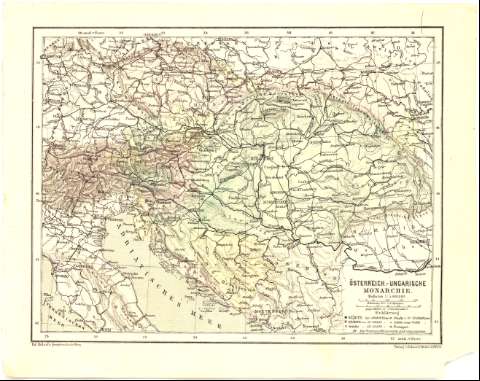
Osterreich - Ungarische Monarchie
Section: Maps, plans and nautical charts
Uniform title: Europa. Central. Mapas generales. 1:5000000 (187)
Title: Osterreich - Ungarische Monarchie / Ed. Hotzel's geogr. Institut in Wien
Material or type of resouce Area: Escala 1:5000000 ; [proyec. cónica]
Publication: In Wien : Verlag v. Eduard Holzel, 187-
Physical description: 1 mapa : col. ; 22,1x28,8 cm en h. de 26,2x33,3 cm
Content type: Imagen cartográfica
Media type: computadora
Carrier type: recurso en línea
Notes: Comprende el norte de Italia, el este de Alemania, el oeste de Polonia y Rumania, Hungria, Austria y el norte de Yugoslavia
Escalas gráficas de 200 kilómetros [= 4 cm] y 30 millas geográficas [= 4,5 cm]. Coordenadas referidas al meridiano de Hierro (E27°10'-E44°30'/N50°20'-N41°50'). Red geográfica de 2° en 2°
Relieve representado por normales
Tabla de signos convencionales para indicar núcleos de población de distinta categoria
Materia / lugar / evento: Mapas generales
Divisiones administrativas
S.XIX
Italia
Alemania
Polonia
Hungría
Austria
Yugoslavia
Other authors: Holzel, Eduard
UDC: 912(4-191.2)'1870/1879'
(45-17)
(430-11)
(438 -15)
(436)
(497.1-17)
Type of publication:
![]() Maps
Maps
Préstamo:
![]() Disponible
Disponible


