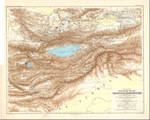
Originalkarte des Centralen Theiles des Thianschan -...


 Maps, plans and nautical charts
Originalkarte des Centralen Theiles des Thianschan - Gebirgssystems (1875)
Maps, plans and nautical charts
Originalkarte des Centralen Theiles des Thianschan - Gebirgssystems (1875)
 Disponible Holdings
 Section: Maps, plans and nautical charts
Uniform title: TURKESTAN. E. Mapas generales. 1875 (1864-1868). 1:1100000
Title: Originalkarte des Centralen Theiles des Thianschan - Gebirgssystems / zur Ubersicht von N.A. Sewerzoff's Reisen 1864/8... ; Von A. Petermann ; Gezeichnet v. H. Habenicht
Material or type of resouce Area: Escala 1:1100000 ; [proyec. cónica] (E73°55'-E82°00'/N44°20'-N39°35')
Publication: Gotha : Justus Perthes, 1875 (Berlin : Lith. Institut v. Wilh. Grece)
Physical description: 1 mapa : col. ; 50'2x54'5 cm en h. de 55'8x69'9 cm
Content type: Imagen cartográfica
Media type: computadora
Carrier type: recurso en línea
Notes: Comprende las repúblicas de Kirguizistán y Kazajstán en la región del Turquistán
Pertenece al 'Petermann's Geographische Mittheilungen, Erganzung Sheft, N 42'
Escalas gráficas de 90 verstas rusas [= 8'6 cm] y 14 millas alemanas de 15 al grado [= 9'3 cm]. Red geográfica de 1° en 1°
Relieve representado por sombreado
Tabla de signos convencionales para indicar rutas, ruinas, pastos etc
Materia / lugar / evento: Mapas generales
1868
Kirguizistán
Kazajstán
Other authors: Habenicht, Hermann
Perthes, Justus, 1749-1816
Grece, Wilhelm
UDC: 912(47-328 Turquestán)'1864/1868'
(47-328 Kargeeizistán)
(47-328 Karzajstán)
Type of publication:
Maps
Rights:
Préstamo:
Disponible
