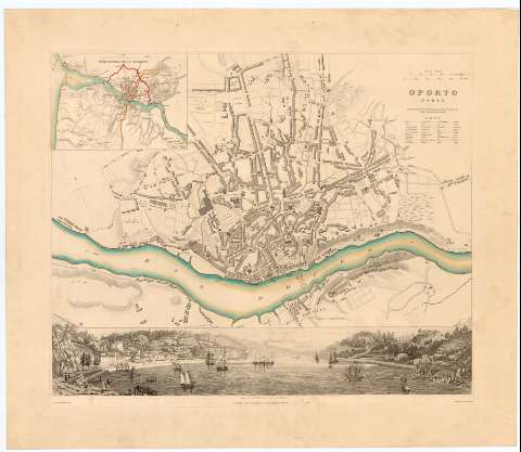
Oporto : (Porto)


Section: Maps, plans and nautical charts
Uniform title: OPORTO (Portugal). Planos de población (1844). 1:9700
Title: Oporto : (Porto) / Drawn by W.B. Clarke Archt. ; Engraved by J. Henshail ; Published under the Superintendence of the Society for the Diffusion of Useful Knowledge
Material or type of resouce Area: Escala [1:9700], 500 Metres [= 5,2 cm]
Publication: London : Chas. Knight & Co. 22 Ludgate Street, 1844 ?
Physical description: 1 plano : col., montado sobre tela ; 31,1x38 cm en h. de 40x46,3 cm
Content type: Imagen cartográfica
Media type: computadora
Carrier type: recurso en línea
Notes: Escala gráfica de 400 Yards = 1/4 Mile [= 4,2 cm]
Orientado con estrella en cuadrante
Relieve representado por sombreado
Tabla con términos utilizados en ingles y portugués
En el margen inferior : 195
Indica el curso del río Duero con flechas
Inserta : The environs of Oporto. - Escala [ca. 1:80500], 2 Miles [= 4 cm] - - View of Oporto from Torre da Marca
Materia / lugar / evento: Planos de población
1844
Vila Nova de Gaia
Other authors: Clarke, W. B
Henshall, J
Charles Knight and Co
UDC: 912:314(469 Oporto)'1844'(084.3)
(469 Villa Nova de Gaya)
Type of publication:
 Maps
Maps
Rights:
Préstamo:
 Disponible
