North America


Section: Maps, plans and nautical charts
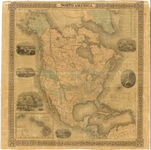
Uniform title: AMERICA DEL NORTE. Mapas generales (1855). 1:16834999
Title: North America
Material or type of resouce Area: [ca. 1:16834999]
Publication: New York : Published by J. H. Colton & Co. N° 172 Willian St., 1855
Physical description: 1 mapa : col., montado sobre tela y barnizado ; 67 x 63 cm
Content type: Imagen cartográfica
Media type: computadora
Carrier type: recurso en línea
Notes: Comprende además América Central y parte de la costa septentrional de América del Sur
Escala gráfica de 600 millas [= 6'6 cm]. Proyec. ortográfica oblicua.
Coordenadas referidas al meridiano de Washington (O 147°-O 47°/N 75°-N 5°)
Relieve representado por normales
Tabla de datos estadísticos sobre la extensión y población de diversas áreas políticas y estados de Estados Unidos, y tabla de distancias en millas, entre diversas ciudades
Coloreadas las fronteras en varios tonos
Enmarcado por greca
Inserta 6 vistas de paisajes
En el ángulo inferior izquierdo inserta: "Hawaiian Group or Sandwich Islands". [ca. 1:3831414]. Incluye tabla con datos de población
Materia / lugar / evento: Mapas generales
Fronteras
Núcleos de población
Islas
1855
Estados Unidos
América del Norte
América Central
Hawái
Other authors: J. H. Colton & Co
UDC: (7/728)
Type of publication:
 Maps
Maps
Rights:
Préstamo:
 Disponible
