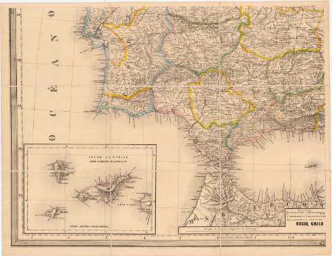
Mapa de los ferrocarriles de España y Portugal


 Disponible Holdings
 Section: Maps, plans and nautical charts
Uniform title: ESPAÑA. S. Mapas generales (1883?). 1:1000000
Title: Mapa de los ferrocarriles de España y Portugal / Rubio, Grilo y Vitturi, Grabado por F. Kraus
Material or type of resouce Area: Escala 1:1000000 ; [proy. cónico]
Publication: [España : [Editor no identificado], 1883?]
Physical description: 1 mapa en 2 hoja : col., montado sobre tela ; 59 x 155 cm, en hoja de 59 x 78 cm
Content type: Imagen cartográfica
Media type: computadora
Carrier type: recurso en línea
Notes: Comprende desde los 39°10' N de latitud hasta la parte septentrional de Marruecos, al faltar las hojas superiores de las que conforman el mapa
Título redactado a partir del contenido del docuemnto
Fecha tomada del catálogo del SGE: "Mapas generales de España. Siglos XV a XIX". 1965, p. 194
Escala también dada en forma gráfica, de 200 km y 40 leguas españolas de 20000 pies. Coordenadas referidas al meridiano de Madrid (O 7°10'--E 9°00'/N 39°10'--N 34°11'). Red geográfica de 1° en 1°. Mención nominal de los puntos cardianales
Orografía por sombreado
Tabla de signos convencionales para indicar núcleos de población de distinta categoría, líneas de ferrocarril, carreteras, canales y estaciones geográficas
Límites territoriales entre las provincias destacados con color
Inserta: "Islas Canarias : parte occidental de la provincia". Coordenadas referidas al meridiano de Madrid (O 14°55'--O 11°52'/N 29°09'--N 27°20') ; "Islas Canarias : parte oriental de la provincia". Coordenadas referidas al meridiano de Madrid (O 12°21'--O 9°18'/N 29°27'--N 27°38'). Ambos a escala [1:1000000]
Materia / lugar / evento: Mapas generales
Divisiones administrativas
Líneas ferroviarias
1883
Portugal
África
UDC: 912:625.12:(1-35)(460-13)(469-13)(6-16)"1883"
460-13
469-13
6-16
Type of publication:
 Maps
Maps
Rights:
Préstamo:
Disponible
