Map to illustrate the routes of Messrs. Michie and Grant...


 Maps, plans and nautical charts
Map to illustrate the routes of Messrs. Michie and Grant the former from Tien - tsin to Markden in Manchuria the... (1863)
Maps, plans and nautical charts
Map to illustrate the routes of Messrs. Michie and Grant the former from Tien - tsin to Markden in Manchuria the... (1863)
 Disponible Holdings
 Section: Maps, plans and nautical charts
Uniform title: POHAI (Mar). Mapas itinerarios (1863). 1:2300000
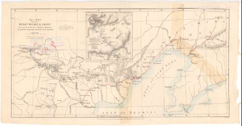
Title: Map to illustrate the routes of Messrs. Michie and Grant the former from Tien - tsin to Markden in Manchuria the latter from Peking across te Desert of Gobi to Kiachtas / Edwd. Weller
Material or type of resouce Area: Escala [ca. 1:2300000], 50 english miles [= 3,5 cm] ; [proyec. cónica] (E114°10'-E123°40'/N42°10'-N38°40')
Publication: London : John Murray Albemarle Street, 1863
Physical description: 1 mapa : col. ; 22,2x42,8 cm
Content type: Imagen cartográfica
Media type: computadora
Carrier type: recurso en línea
Notes: Presenta la zona comprendida entre Kalgan hasta Lushum
Red geográfica de 1° en 1°
Relieve representado por normales
Nota relativa a los topónimos usados por el autor
En el margen inferior, 'Pubd. for the Journal of the Royal Geographical Society'
Indica las rutas de los expedicionarios Michie y Grant mediante clave cromática
Inserta : [Map of] continuation of Mr. Grant's Route : on a reduced scala. - Escala [ca. 1:14600000]
Materia / lugar / evento: Mapas itinerarios
Expediciones
1863
Zhangjiakou
Beijing
Port Arthur
Other authors: Weller, Edward
Murray, John
UDC: 912:[656.02:910.4](26 Pohai)'1863'
(510 Kalgan)
(510 Pekin)
(510 Lushum)
Type of publication:
Maps
Rights:
Préstamo:
Disponible
