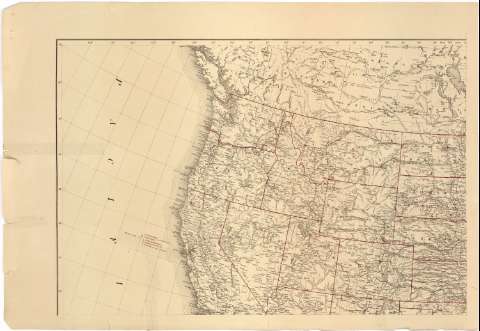
Map of the United States


Section: Maps, plans and nautical charts
Uniform title: Estados Unidos. Mapas generales (1889). 1:5000000
Title: Map of the United States / Prepared in the Office of the Chief of Engineers, U.S. under the direction of Brig. Gen. John Newton, Chief of Engrs. But. Major General, U.S.A. ; by W.W. Winship
Edición: Corrected to December 1889
Material or type of resouce Area: Escala 1:5000000 ; [proy. de Bonne] (O 139°--O 53°/N 55°--N 17°)
Publication: [Lugar de publicación no identificado] : [Editor no identificado]], 1889
Physical description: 1 mapa en 4 hoja : col. ; 88 x 131 cm, hoja de 52 x 76 cm
Content type: Imagen cartográfica
Media type: computadora
Carrier type: recurso en línea
Notes: Escala gráfica de 300 millas [= 9'7 cm]. Coordenadas también referidas al meridiano de Washington (O 62°--E 24°). Red geográfica de 2° en 2°
Indica la situación de algunos fuertes y puestos militares por medio de banderines de color carmín
Tabla explicativa de símbolos convencionales
Sobre el título figura un escudo posiblemente del Departamento de Guerra
Inserta: "Teritory of Alaska". Escala 1:20000000, 700 millas [= 5'6 cm]
Materia / lugar / evento: Mapas generales
Fortificaciones
1889
México
Caribe (Mar)
Other authors: Winship, W.W
Newton, John
Estados Unidos. War Department
Estados Unidos. Army. Office of the Chief of Engineers
UDC: (73)
Type of publication:
 Maps
Maps
Rights:
Préstamo:
 Disponible
