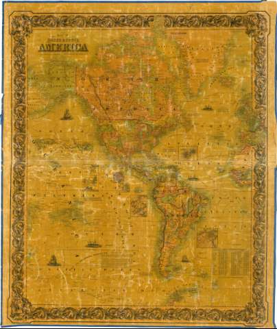
Map of North & South America


Section: Maps, plans and nautical charts
Uniform title: AMERICA. Mapas políticos (1855). 1:24154589
Title: Map of North & South America / Published by J. H. Colton & Co. N° 172 William St. New York, 1855
Material or type of resouce Area: [Ca. 1:24154589] (O 180°-O 0°/N 78°-N 65°)
Publication: New York : Published by J. H. Colton & Co., 1855
Physical description: 1 mapa : col., montado sobre tela y barnizado ; 121 x 102 cm
Content type: Imagen cartográfica
Media type: computadora
Carrier type: recurso en línea
Notes: Comprende además una pequeña parte de la costa este de Asia y oeste de Europa y Africa
Escala hallada a partir de un grado de latitud [= 0,46 cm]. Red geográfica de 15° en 15°
Relieve por normales
Indica sondas batimétricas
Señala las líneas de derrota seguidas por varios navegantes
Notas explicativas sobre la determinación de la escala y de los sucesos más significativos acaecidos durante las expediciones. Relación de las distancias existentes entre los principales núcleos de población, respecto a las ciudades de Londres, Nueva York y Nueva Orleans
Inserta: "The Nicaragua Route" ; "Harbor of San Juan de Nicaragua" ; "Isthmus of Thehuantepec" ; "Manzanilla J. Aspinwallcity" ; "City of Panama" ; "Isthmus of Panama" ; "The Bermuda Islands" ; "Rio de Janeiro"
Orlado en greca decorada con motivos vegetales. Representación de naviós en el mar
Materia / lugar / evento: Expediciones geográficas
Mapas generales
Derroteros
Costas
Núcleos de población
1855
Asia
Europa
África
América
Other authors: J. H. Colton & Co
UDC: 912:32+910.4:527.6(7/8)"1855"
7/8
Type of publication:
 Maps
Maps
Rights:
Préstamo:
 Disponible
