Map of Battlefield of Big Black River Bridge Mississippi...


 Maps, plans and nautical charts
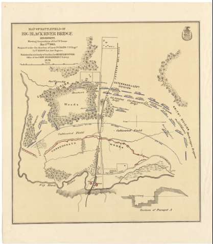
Map of Battlefield of Big Black River Bridge Mississippi Showing the positions of the U. S. Troops May 17 th. 1863 (1876)
Maps, plans and nautical charts
Map of Battlefield of Big Black River Bridge Mississippi Showing the positions of the U. S. Troops May 17 th. 1863 (1876)
 Disponible Holdings
 Section: Maps, plans and nautical charts
Uniform title: BIG BLACK (Estados Unidos) (Mississippi) (Río). Operaciones bélicas. 1876 (1863). 1:7300
Title: Map of Battlefield of Big Black River Bridge Mississippi Showing the positions of the U. S. Troops May 17 th. 1863 / Prepared under the direction of Lieut P. C. Hains. U.S. Engrs by F. Mason Act Asst. Engineer ; published by authority of the Hon. the Secretary of War Office of the Chief of Engineers U.S. Army 1876
Material or type of resouce Area: Escala [ca. 1:7300]
Publication: [Washington] : Secretary of War, Office of the Chief of Engineers U.S. Army, 1876
Physical description: 1 mapa : col. ; 48 x 45 cm
Content type: Imagen cartográfica
Media type: computadora
Carrier type: recurso en línea
Notes: Presenta la ubicación de diversos batallones del ejército estadounidense, así como el parapeto defensivo levantado por las fuerzas confederadas, y un perfil de éste último
Escala gráfica de 800 yardas [= 10 cm]
Relieve de perfil. Orientado con flecha
Impreso coloreado en rojo y azul
Materia / lugar / evento: Operaciones bélicas
Estrategia militar
Ríos
1863
Mississippi
Estados Unidos
Other authors: Mason, F
Hains, P. C
Estados Unidos. War Department
Estados Unidos. Army. Office of the Chief of Engineers
UDC: 912:355.4:355.43(762)"1863"
762
Type of publication:
Maps
Rights:
Préstamo:
Disponible
