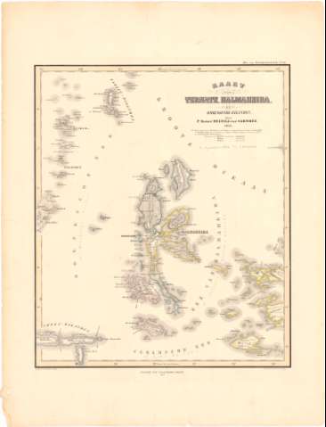
Kaart van Ternate Halmaheira en Omringende Eilanden


 Disponible Holdings
 Section: Maps, plans and nautical charts
Title: Kaart van Ternate Halmaheira en Omringende Eilanden / door P. Baron Melvill van Carnbee ; geteckd. Cronenberg en wolff
Material or type of resouce Area: Escala [ca. 1:2000000] (E125°00'-E131°05'/N4°58'-S2°10')
Publication: [Amsterdam ?] : nitgave van Gualtherus Kolff, 1869 (Breda : Lithogr. Etabt. v.A.J. Bogaerts)
Physical description: 1 mapa : col. ; 38x32,3 cm en h. de 53,7x40,8 cm
Content type: Imagen cartográfica
Media type: computadora
Carrier type: recurso en línea
Notes: Escala hallada a partir de un grado de la latitud [= 5 cm]
Relieve representado por normales
Pertenece al 'Atlas van Noderlandsch Indie. - N 21'
Materia / lugar / evento: Mapas generales
Islas
Topónimos antiguos
1869
Ternate (Isla)
Halmahera (Isla)
Other authors: Melvill van Carnbee, P Barón
Cronenberg
Bogaerts, A. J
Kolff, Gualtherus
UDC: 912:551.42(91 Halmahera, isla)'1854/1869'
(91 Teruate, isla)
Type of publication:
 Maps
Maps
Rights:
Préstamo:
Disponible
