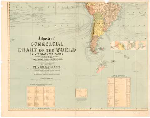
Johnstons' Commercial Chart of the World on Mercators...


 Maps, plans and nautical charts
Johnstons' Commercial Chart of the World on Mercators Projection... : with an Enlarged Map of Central Europe... (186- ?)
Maps, plans and nautical charts
Johnstons' Commercial Chart of the World on Mercators Projection... : with an Enlarged Map of Central Europe... (186- ?)
 Disponible Holdings
 Section: Maps, plans and nautical charts
Uniform title: Mundo. Geografía comercial (186). 1:23000000
Title: Johnstons' Commercial Chart of the World on Mercators Projection... : with an Enlarged Map of Central Europe... / Constructed and Engraver by W. & A.K. Johnston...
Material or type of resouce Area: Escala [ca. 1:23000000 ; proyec. Mercator]
Publication: Edimburgh : W. & A.K. Johnston, [186- ?]
Physical description: 1 planisferio en 4 h. : col. ; h. de 74x94 cm
Content type: Imagen cartográfica
Media type: computadora
Carrier type: recurso en línea
Notes: Presenta además 18 mapas de detalle
Escala hallada a partir de un grado de latitud [= 0'48 cm] en el Ecuador. Red geográfica de 10° en 10°. Orientado con lis. Figura gráfico de declinación magnética
Relieve representado por sombreado
Tabla de distancias entre los principales puertos y de colonias británicas con modo y fecha de adquisición. Tabla de signos convencionales para indicar la dirección de las corrientes la situación de las colonias británicas, rutas marítimas, etc.
Nota sobre distancias, rumbos y orientaciones
Materia / lugar / evento: Geografía comercial
S.XIX
Other authors: W. & A.K. Johnston Limited
UDC: 912:339.1(100)'1860/1869'
100
Type of publication:
Maps
Rights:
Préstamo:
Disponible
