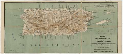
Isla de Puerto Rico


Section: Maps, plans and nautical charts
Uniform title: Puerto Rico. Mapas generales. 1:600000 (1880?)
Title: Isla de Puerto Rico
Material or type of resouce Area: Escala 1:600000
Publication: [Madrid : Litografia e Imprenta de la Biblioteca Universal, 1880]
Physical description: 1 mapa : col., montado sobre tela20 x 43 cm ; 20 x 43 cm
Content type: Imagen cartográfica
Media type: computadora
Carrier type: recurso en línea
Notes: Escala gráfica de 30 kms. Coordenadas referidas a un meridiano que no se especifica (O 63°51'--O 61°24'/N 18°38'--N 17°27'). Red geográfica de 30' een 30'
Relieve representado por sombreado
Tabla de signos convencionales para indicar ciudades, aldeas y caminos
Pertenece al "Atlas Geográfico Descrliptivo de la Peninsula Ibérica Islas Baleares, Canarias y Posesiones Españolas de Ultramar" por el comandante graduado Capitán de Infantería D. Emilio Valverde y Alvarez .- Madrid : Litografia e Imprenta de la Biblioteca Universal, 1880
Documento firmado por José García Puchol
Materia / lugar / evento: Mapas generales
Other authors: Valverde y Álvarez, Emilio, 1848-1894
Imprenta y Litografía de la Biblioteca Universal (Madrid)
UDC: 912(729.5)"1880">(729.5)
Type of publication:
 Maps
Maps
Rights:
Préstamo:
 Disponible
