Geometrical Survey of the Province of Britaniay, Ato...


 Maps, plans and nautical charts
Geometrical Survey of the Province of Britaniay, Ato wichi chebeen added Lowes Printon And Lower Normandy with Part... (1795)
Maps, plans and nautical charts
Geometrical Survey of the Province of Britaniay, Ato wichi chebeen added Lowes Printon And Lower Normandy with Part... (1795)
 Disponible Holdings
 Section: Maps, plans and nautical charts
Uniform title: FRANCIA. NO. Mapas generales. 1:350000 (1795)
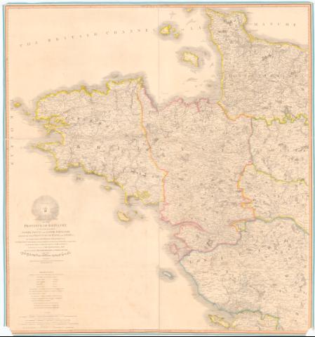
Title: Geometrical Survey of the Province of Britaniay, Ato wichi chebeen added Lowes Printon And Lower Normandy with Part of The Provinces y Maine and Anjonez : The while including The Modern Departments of Finisterre este Un Nord, Morbihau, Basse Lowe, Ille et Vilaine and la Manche ; also Part of Duse of Calvados L'Orne, la man enne, Maine et Loire La Vendreéac
Material or type of resouce Area: Escala [ca. 1:350000, 15 Midding League of France cach 3000 geometrical pades or 2500 Toises] [= 20,5 cm]
Publication: London : Published by W. Faden Geographer to His Majesty and to H.R.H. The Prince of Wales charing Cross, 1795
Physical description: 1 mapa : Col. montado sobre tela ; 111x114 cm, pleg. en 67x55 cm
Notes: Escalas graficas de 10 Manne Leagues each of 3 Minutes of latitude and Equal to 2853 Toises, 40 Britich Statute Mile each of 827 Toises etc.
Cordenadas referidas al meridiano de Londres (O5°50'-O0°00'-N49°45'-N46°10'). Recuadro geografico de 15' en 15'
Relieve representado por sombreado
Nota sobre los diferentes divisiones administrativas del mapa
Indice masas forestales
FRN
Materia / lugar / evento: Mapas generales
Divisiones administrativas
1795
Baja Normandía
Anjou (Ducado)
Bretaña
Francia
Other authors: Faden, William, 1749-1836
UDC: 912:(44-16)'1795'
(44-328 Bretaña)
(44-328 Normandia)
(44-328 Anjou)
Type of publication:
Maps
Rights:
Préstamo:
Disponible
