Chomgraphische Krieces : Carte von Zwickau bis Wurtzburg...


 Maps, plans and nautical charts
Chomgraphische Krieces : Carte von Zwickau bis Wurtzburg... (1759)
Maps, plans and nautical charts
Chomgraphische Krieces : Carte von Zwickau bis Wurtzburg... (1759)
 Disponible Holdings
 Section: Maps, plans and nautical charts
Uniform title: ALEMANIA. Central. Mapas generales (1759). 1:68000
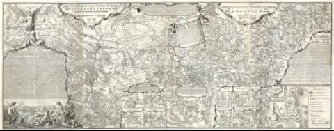
Title: Chomgraphische Krieces : Carte von Zwickau bis Wurtzburg... / von Petri Maj. et Ingen
Material or type of resouce Area: [Ca. 1:68000], 1 Meile [= 11,1 cm]
Publication: [Deutschland? : [Editor no identificado]], 1759
Physical description: 1 mapa ; 237,4 x 91,7 cm
Content type: Imagen cartográfica
Media type: computadora
Carrier type: recurso en línea
Notes: Presenta además once planos de los campamentos existentes en distintas ciudades
Relieve representado por normales
Tabla de signos convencionales para indicar fortificaciones, edificios religiosos, caminos, etc
Indica masas forestales y las posiciones de los ejércitos
Título en cartela en forma de lienzo sujetada por dos ángeles, en la parte superior y en la derecha lleva dos cartelas con texto, y en la parte izquierda lleva una gran cartela con representaciones humanas, en un paisaje y al fondo representación de una batalla, en la zona superior de la misma hay un ángel tocando la trompeta
Materia / lugar / evento: Mapas generales
Guerras
Estrategia militar
Campamentos militares
Fortificaciones
1759
Zwickau
Wurzburgo
Alemania
Other authors: Petri, Isaak Jakob von, 1701-1777
UDC: 912:[355.4:355.43:355.67:623.2](430-191.2)'1759'
(430 Zwickau)
(430 Wurzburg)
Type of publication:
Maps
Rights:
Préstamo:
Disponible
