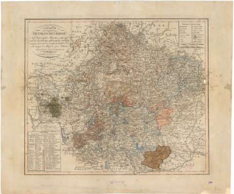
Charte von dem Frankischen Kreise


Section: Maps, plans and nautical charts
Uniform title: Alemania. Mapas generales (1805). 1:570000
Title: Charte von dem Frankischen Kreise / Gezeichnet von F.H. Kreybich
Material or type of resouce Area: [Ca. 1:570000], 5 Geograph ed. deutsche Meilen 15 auf, 1 grad [= 6,5 cm] ; [proyec. cónica]
Publication: Weimar : im Verlage des ge roar. Instit, 1805
Physical description: 1 mapa : col. ; 45 x 53 cm en h. de 55,7 x 66,5 cm
Content type: Imagen cartográfica
Media type: computadora
Carrier type: recurso en línea
Notes: Escala gráfica de 8 "Stundenveges 25 auf einen grad." [= 6 cm] Coordenadas referidas, al parecer, al meridiano de hierro (E 26°-E 30°/N 50°55'-N 48°43'). Red geográfica de 30' en 30'
Relieve representado por normales
Tabla de signos convencionales para indicar núcleos principales de población, montañas y bosques
Leyenda explicativa de los colores y abreviaturas utilizadas
Título enmarcado en cartela
Procede de la "Colección Rico y Sinobas"
Other authors: Kreibich, Franz Jacob Heinrich
UDC: 912(430-13)'1805'
430-13
Type of publication:
 Maps
Maps
Rights:
Préstamo:
 Disponible
