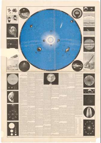
Carte du Sisteme Solaire]


Section: Maps, plans and nautical charts
Uniform title: Sistema solar. Mapas Celestes (184-). Escala indeterminada
Title: Carte du Sisteme Solaire] / T.H. Gheldolf, Graveur
Material or type of resouce Area: Escala indeterminada
Publication: Baux ? : Lith. L. Mertens, Rue du Poincon 8, [184-]
Physical description: 1 carta celeste : col. ; 156x97'6 cm
Content type: Imagen cartográfica
Media type: computadora
Carrier type: recurso en línea
Notes: Presenta además 25 figuras cosmográficas
Leyenda explicativa de astronomia con datos de todos los planetas
Materia / lugar / evento: Mapas celestes
1849
Other authors: Gheldolf, T.H
Mertens, L
UDC: 912:[523/524](523)'1840/1849'
Type of publication:
 Maps
Maps
Rights:
Préstamo:
 Disponible
