A New General Chart of the Atlantic or Western Ocean and...


 Maps, plans and nautical charts
A New General Chart of the Atlantic or Western Ocean and Adjacent Seas, including the Coast of Europe and Africa... (1794)
Maps, plans and nautical charts
A New General Chart of the Atlantic or Western Ocean and Adjacent Seas, including the Coast of Europe and Africa... (1794)
 Disponible Holdings
 Section: Maps, plans and nautical charts
Uniform title: Océano Atlántico. Cartas náuticas. 1:11.000.000 (1794)
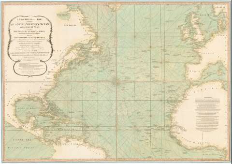
Title: A New General Chart of the Atlantic or Western Ocean and Adjacent Seas, including the Coast of Europe and Africa from 60 Degrees North Latitude to the Equator, and also the Opposite Coast of América / By Mr. De Fleurieu ..
Material or type of resouce Area: [Ca. 1:11000000 ; proyec. Mercator]
Publication: London : Published by Laurie & Whittle N 53 Fleet Street, 1794
Physical description: 1 carta náutica : col., montado sobre tela ; 101 x 143 cm, pleg. en 51,2 x 71,5 cm
Content type: Imagen cartográfica
Media type: computadora
Carrier type: recurso en línea
Notes: Comprende parte de América, Europa y Africa
Escala hallada a partir de un grado de latitud [= 1 cm]. Coordenadas referidas al meridiano de Londres (O 103°-E 13°/N 61°-N 0°) y referidas al meridiano de Hierro. Red geográfica de 10° en 10°. Orientado con lis en nudo de rumbos
Indica veriles, bajos, fondeaderos y sondas batimétricas
Tabla de signos convencionales para indicar lugares según la determinación de la latitud
Other authors: Fleurieu, Charles Pierre Claret, comte de, 1738-1810
Robert Laurie and James Whittle
UDC: 912:551.46(261)'1794'
261
Type of publication:
Maps
Rights:
Préstamo:
Disponible
