A correct map of France, according The New Divisions into...


 Maps, plans and nautical charts
A correct map of France, according The New Divisions into Metropolitan circles, Departaments & Distrits, : as... (London : Published by Wm. Faden. Geogr. to His Majesty... Charing Cross)
Maps, plans and nautical charts
A correct map of France, according The New Divisions into Metropolitan circles, Departaments & Distrits, : as... (London : Published by Wm. Faden. Geogr. to His Majesty... Charing Cross)
 Disponible Holdings
 Section: Maps, plans and nautical charts
Uniform title: Francia. Mapas generales. 1:900000 (1806)
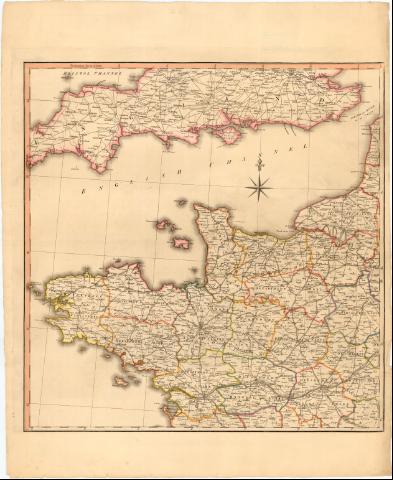
Title: A correct map of France, according The New Divisions into Metropolitan circles, Departaments & Distrits, : as Decreed by the National Asembly, January 15 th. 1790 / from a Reduced copy of Monsr. Cassini's Large map. With the addition of the adjacent countries, from the latest surveys ; Neele sculp 352 strand
Material or type of resouce Area: Escala [ca. 1:900000], 30 Common French Leagues 25 to a Degre [= 14,5 cm]
Publication: London : Published by Wm. Faden. Geogr. to His Majesty... Charing Cross (<, April 18 1806)
Physical description: 1 mapa en 4 h. : col. ; h. de 77,4x63,5 cm
Notes: Escala gráfica ademas de 80 Britisch Miles 69 1/2 to a Degre [= 13,9 cm] Coordenadas referidas al meridiano de Paris (O6°35'-E5°40'/N46°45'-N42°00') Orientado con lis en rosa de los vientos
Relieve de Perfil
Tabla de signos convencionales para indicar divisiones administrativas
Nota sobre 'The Two additional Departements of Mont Blanc, an The Maritem Alps, have been decred sunce the Conquest of Savoy, and the County of Nice'
Procede de la Coleccion 'Rico y Sinobás' figurando sello de la misma, con n '22 al 25'
FRN
Materia / lugar / evento: Mapas generales
Divisiones administrativas
1806
Other authors: Cassini de Thury, César François, 1714-1784
Faden, William, 1749-1836
Neele, Samuel John, 1758-1824
UDC: 912(44-2/-5)'1806'
44
Type of publication:
Maps
Rights:
Préstamo:
Disponible
