[Itinerario entre Casas de D. Pedro, Pela, Madrigalejo y...


 Maps, plans and nautical charts
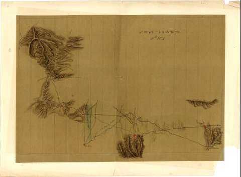
[Itinerario entre Casas de D. Pedro, Pela, Madrigalejo y Río Alcollarín] (1820?)
Maps, plans and nautical charts
[Itinerario entre Casas de D. Pedro, Pela, Madrigalejo y Río Alcollarín] (1820?)
 Disponible Holdings
 Section: Maps, plans and nautical charts
Uniform title: Extremadura. Mapas itinerarios (1820). 1:20.000
Title: [Itinerario entre Casas de D. Pedro, Pela, Madrigalejo y Río Alcollarín]
Material or type of resouce Area: Escala [ca. 1:20000]
Publication: [1820?]
Physical description: 1 mapa : ms., col., montado sobre papel ; 51,9 x 69,3 cm en h. de 62,1 x 79,3 cm, pleg. en 62,1 x 41 cm
Content type: Imagen cartográfica
Media type: computadora
Carrier type: recurso en línea
Notes: Título propio tomado del Catálogo del Servicio Geográfico del Ejército: "Extremadura. Siglos XVIII a XIX". 1972, p. 13
Relieve representado por sombreado
Manuscrito a plumilla en tinta negra y azul y coloreado la acuarela en varios colores
Indica núcleos de población de distinta categoría y caminos
En el margen superior derecho: "17l.N118=4-4-B-n781Fll.n4", y en el inferior izquierdo: "Recibido el 15 Octubre 1858, costó 60 francos"
Copia enviada por el Depósito de la Guerra Francés por gestión de D. Francisco Coello
Materia / lugar / evento: Mapas itinerarios
1820
Casas de Don Pedro
Madrigalejo
Navalvillar de Pela
Alcollarín
UDC: 460.25
Type of publication:
Maps
Rights:
Préstamo:
Disponible
