Map of the British Empire in America with the French and...


 Maps, plans and nautical charts
Map of the British Empire in America with the French and Spanish settlements adjacent thereto (1733)
Maps, plans and nautical charts
Map of the British Empire in America with the French and Spanish settlements adjacent thereto (1733)
 Disponible Holdings
 Section: Maps, plans and nautical charts
Uniform title: AMERICA. Mapas generales. 1:3000000 (1733)
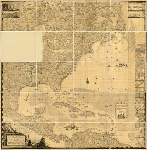
Title: Map of the British Empire in America with the French and Spanish settlements adjacent thereto / by Henry Popple ; C. Lempriere inv. & del ; B. Baron sculp
Material or type of resouce Area: [Ca. 1:2780000]
Publication: London : Engrav'd by Willm. Henry Toms, 1733
Physical description: 1 mapa en 2 h. : montado sobre tela ; 242 x 236 cm en h. de 150 x 238 cm
Content type: Imagen cartográfica
Media type: computadora
Carrier type: recurso en línea
Notes: Comprende la mitad oriental de América del Norte, desde el Lago Sioux y la bahía James en Canadá, hasta el estado de Surinam y parte septentrional de Colombia
Presenta, además, vistas de "Fall of Niagara", "Mexico", "Quebec" y de "Nueva York" y mapas de "The Harbour of Placentia", "The Harbourt of Anapolis Royal", "Boston Harbour", "New york and Perth Amboy, Harbours", "The Town and Harbour of in South Carolina", "The Bermuda or Summer Islands", "Harbour of St Agustine", "The Harbour of Province", "The Havana", "Bay of Satiago in Cuba", "Kingston Harbours in Jamaica", "A Plan of the Harbour of Port Antonio in Jamaica", "Fort Royal in Martinica", "The Island of Barnadoes", "Antigua", "Cartagene on the Coast of New Spain" y "Harbour of Porto Bello"
Dedicatoria: "To the Queen's most Excellent Majesty This map is most humbly inscribed by your Majesty's most Dutiful, most Obedient, and most Humble Servant Henry Popple"
Escala hallada a partir de un grado de latitud [= 4 cm]. Proyec. Mercator. Coordenadas referidas a un meridiano que no se especifica (O 107°-O 47°/N 55°-N 5°). Red geográfica de 1 en 1. Orientado con lis en rosa de 16 vientos
Relieve de perfil
Indica sondas batimétricas
Nota relativa a la aprobación del mapa
Señala la dirección de las corrientes marinas en la región del Caribe
En el ángulo inferior: "Sold by S : Harding on the Pavement in St. Martins Lanc, and by W.H Toms Engraver in Union Court near Hatton Garden Holborn"
Título enmarcado en cartela decorada con figuras de indios y colonias, además de motivos vegetales y animales y dedicatoria en cartela decorada con greca y escudo con león y caballo rampantes a cada lado del mismo
Figuran navíos dibujados en el mar
Materia / lugar / evento: Mapas generales
Divisiones administrativas
Corrientes oceánicas
Heráldica
Dibujos
Lagos
Mares
Bahías
Puertos
Etnografía
1733
América
Other authors: Popple, Henry
Lempriere, Clement
Baron, Bernald
Toms, William Henry
UDC: 7/8
Type of publication:
Maps
Rights:
Préstamo:
Disponible
