A New and Accurate Chart of the Coast of Africa, From...


 Maps, plans and nautical charts
A New and Accurate Chart of the Coast of Africa, From Cape Blanco to the River Sierra Leon : With the Navigation of... (176-?)
Maps, plans and nautical charts
A New and Accurate Chart of the Coast of Africa, From Cape Blanco to the River Sierra Leon : With the Navigation of... (176-?)
 Disponible Holdings
 Section: Maps, plans and nautical charts
Uniform title: AFRICA. Mapas generales (1758). 1:1400000
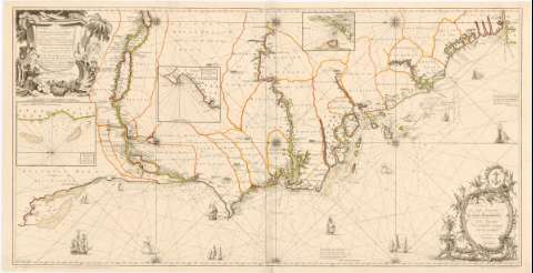
Title: A New and Accurate Chart of the Coast of Africa, From Cape Blanco to the River Sierra Leon : With the Navigation of the Rivers Gambia, Senegal & c. the Rocks, Sands, Soundings, Setting of the Tides, and Time of High Water on that Coast, from an Actual Survey / made By the sieur Lewis Sorel... ; J. Gibson sculp. ; Greennvood delin
Material or type of resouce Area: [Ca. 1:1400000], 30 Leagues 20 to a Degree [= 12 cm] ; [proyec. Mercator]
Publication: London : Sold by A. Miller opposite Catherine street in the Strand London, [176-?]
Physical description: 1 mapa : col., montado sobre tela ; 61,7 x 120 cm, pleg. en 61,7 x 61,3 cm
Content type: Imagen cartográfica
Media type: computadora
Carrier type: recurso en línea
Notes: Dedicatoria: "To the Right Honourable the Lords Commissioners, of the Admiralty, this Chart is Dedicated By their Lordships most obedient Humble servants tho Walker"
Orientado con lis en rosa de 16 vientos prolongados
Relieve de perfil
Indica veriles, bajos y sondas batimétricas
En el ángulo inferior derecho: "this Chart is Enterd in the Hall Book of the Stationers Company, and whoever presumes, to copy the whole or part theof, will be prosecuted according to law"
Nota sobre el original del mapa
Señala núcleos de población mediante cabañas de perfil, selvas y los límites administrativos en color
Título enmarcado en cartela con paisaje africano. Representación de navios en el mar
Inserta: A Draught of the Bay of Portandic. Escala [ca. 1:200000], 3 leguas [= 9 cm] ; Part of the Isle of Bisseau. Escala [ca. 1:200000], 3 leguas [= 7,5 cm] ; ADraught of the Isle of Goree and Adjacent coast. Escala [ca. 1:600000], 5 leguas [= 4,5 cm]
Materia / lugar / evento: Mapas generales
Batimetría
1758
África
Other authors: Sorel, Lewis
Greennvood
Gibson, John
UDC: 912:551.4(6-15)'1758'
6-15
Type of publication:
Maps
Rights:
Préstamo:
Disponible
