Bartholomew's Reduced Survey Map of South Africa coloured...


 Maps, plans and nautical charts
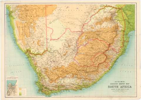
Bartholomew's Reduced Survey Map of South Africa coloured to show height of land (1900)
Maps, plans and nautical charts
Bartholomew's Reduced Survey Map of South Africa coloured to show height of land (1900)
 Disponible Holdings
 Section: Maps, plans and nautical charts
Uniform title: AFRICA. Mapas generales. 1:2500000 (1900)
Title: Bartholomew's Reduced Survey Map of South Africa coloured to show height of land
Material or type of resouce Area: 1:2500000 ; [proyec. estereográfica meridiana] (E14°00'-E33°30'/S21°40'-S34°30')
Publication: Edinburgh : the Edinburgh Geographical Institute, 1900
Physical description: 1 mapa : col., montado sobre tela ; 61,8 x 86,7 cm
Content type: Imagen cartográfica
Media type: computadora
Carrier type: recurso en línea
Notes: Presenta además un mapa de Cape Town
Red geográfica de 1° en 1°
Relieve representado por normales
Tabla de signos convencionales para indicar carreteras y líneas ferroviarias
Leyenda explicativa sobre el lenguaje Nama
En el margen inferior derecho: "Copyright John Bartholomew & Co."
Other authors: John Bartholomew and Son
Edinburgh Geographical Institute
UDC: 912(6-13)'1900'
6-13
Type of publication:
Maps
Rights:
Préstamo:
Disponible
