Map of The Routes in Eastern Africa between Zauzibar the...


 Maps, plans and nautical charts
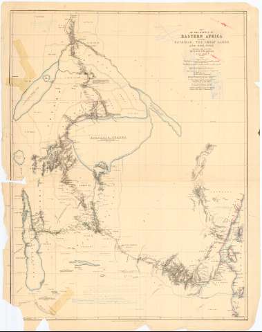
Map of The Routes in Eastern Africa between Zauzibar the Great Lakes and the Nile (1857-1863)
Maps, plans and nautical charts
Map of The Routes in Eastern Africa between Zauzibar the Great Lakes and the Nile (1857-1863)
 Disponible Holdings
 Section: Maps, plans and nautical charts
Uniform title: AFRICA. SE. Mapas generales. 1:2000000 (1857-1863)
Title: Map of The Routes in Eastern Africa between Zauzibar the Great Lakes and the Nile / Explored and surveyed by Capt J.H. Speke
Material or type of resouce Area: [Ca. 1:2000000], 80 Geographical Miles 60-1 [= 8,5 cm] ; [proyec. cilíndrica] (29°0'-E 40°0'/N 5°0'-S 9°0')
Publication: London : Published for the Journal of The Royal Geographical, Society, by J. Murray Albemarle St., 1857-1863
Physical description: 1 mapa : col. ; 75 x 62 cm, pleg. en 43 x 62 cm.
Content type: Imagen cartográfica
Media type: computadora
Carrier type: recurso en línea
Notes: Escala gráfica de "100 English Stat". Red geográfica de 1° en 1°
Relieve representado por normales
Tabla de signos convencionales para indicar las rutas de las expediciones
Notas manuscritas al parecer de D. Francisco Coello
Procede de la "Coleccion Coello"
Materia / lugar / evento: Mapas generales
Itinerarios
Topónimos antiguos
S.XIX
Kenia
Tanzania
África
Other authors: Speke, John Hanning
Murray, John
UDC: 912:(656.02:801.311)(6-12)'1857/1863'
(676.2)
(67 8)
Type of publication:
Maps
Rights:
Préstamo:
Disponible
