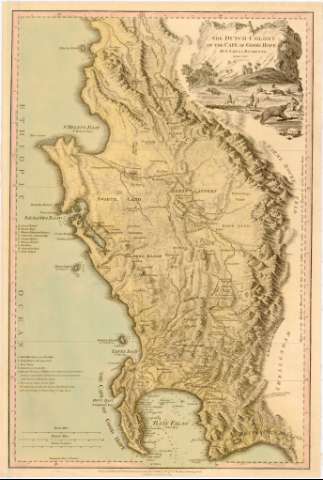
The Dutch Colony of the Cape of Good Hope


 Disponible Holdings
 Section: Maps, plans and nautical charts
Uniform title: SUDAFRICA. S.O. Colonias (1795). 1:530554
Title: The Dutch Colony of the Cape of Good Hope / By L.S. de la Rochette ; Engraved by W. Faden
Edición: Ed. corr.
Material or type of resouce Area: Escala [ca. 1:530554], 30 British Miles [= 9,1]
Publication: London : Published by W. Faden, Successor to the late T. Jefferys Geogrn. to the King, Charing Cross, 1795
Physical description: 1 mapa : col., montado sobre tela ; 51,5x34,7 cm
Content type: Imagen cartográfica
Media type: computadora
Carrier type: recurso en línea
Notes: Corrección de 1795
Escalas gráficas de 6 Dutch [= 8,4 cm] y 8 Nautic Leagues [= 8,4 cm]. Coordenadas referidas al meridiano de Londres (E17°45'-E19°33'/S32°7'-S34°24')
Relieve de perfil
Indica veriles, bajos, fondeaderos y sondas batimetricas
Relación de las alturas de las mesetas, algunos lugares, ciudades y la ruta del ejército británico, indicados por clave alfabética
Nota sobre la medición del mapa hecha en el año 1752 por el Abad de la Caille y su correspondencia en toesas
Titulo enmarcado en paisaje y cacería de elefantes
Other authors: La Rochette, Louis Stanislas D'Arcy de
Faden, William, 1749-1836
UDC: 912:325.45(680-14)'1795'
(680 Buena Esperanza, Cabo)
Type of publication:
 Maps
Maps
Rights:
Préstamo:
Disponible
