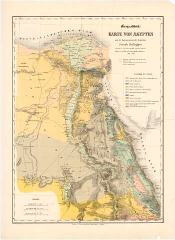
Geognoftische Karte Von Aegyten


Section: Maps, plans and nautical charts
Uniform title: Egipto. Mapas generales. 1:150000 (1842)
Title: Geognoftische Karte Von Aegyten / nach den Bestimmungen des K.K. Bergrathes Joseph Rufsegger
Material or type of resouce Area: Escala [ca. 1:150000]. 15 Deutsche meilen [= 7,5 cm] ; [proyec. cónica]
Publication: Wien : von dem K.K milit geographischen Institute, 1842 (Stuttgart : Verlag der E. Schweizerhart'schen Buchhandlang)
Physical description: 1 mapa : col. ; 64x47 cm en h. de 75x55 cm
Content type: Imagen cartográfica
Media type: computadora
Carrier type: recurso en línea
Notes: Escalas graficas de '60 Geographische Meilen 60 = 1 Grad' [= 7,5 cm], 'Karawannen studen 24 = 1 Graud' [=7,5 cm]. Coordenadas referidas al meridiano de Hierro (E46°35'-E52°20'/N52°15'-N24°0'). Red geografica de 1° en 1°
Relieve representado por sombreado y normales
Relacion de la composición del terreno indicado por clave cromatica
Tabla de signos convencionales para indicar estaciones, caminos etc
Procede de la 'Colección Coello'
Materia / lugar / evento: Mapas generales
1842
UDC: 912(620)'1842'
620
Type of publication:
 Maps
Maps
Rights:
Préstamo:
 Disponible
