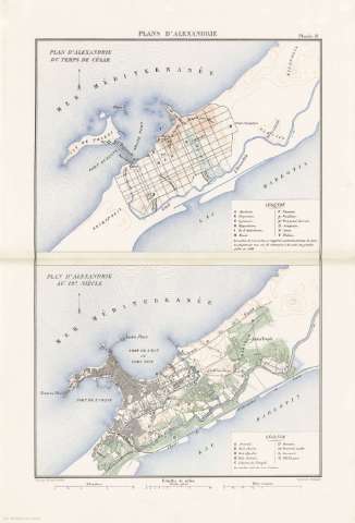
Plans D'Alexandrie


 Disponible Holdings
 Section: Maps, plans and nautical charts
Title: Plans D'Alexandrie / gravé par Erhard Schiéble
Author: Erhard Schièble, Georges, 1821-1880
Material or type of resouce Area: 1:40000
Publication: [París] : Imprimerie Nationale, [1887]
Physical description: 2 mapas en 1 h. : col. ; 52 x 35 cm, pleg. en 26 x 35 cm
Content type: Imagen cartográfica
Media type: computadora
Carrier type: recurso en línea
Notes: Escala gráfica además en "Kilométres" y "Milles Romains"
Relieve representado por curvas de nivel
Figura leyenda alfabética de los lugares importantes del mapa
Copia digital. España : Ministerio de Cultura y Deporte. Subdirección General de Coordinación Bibliotecaria, 2010
Other titles: En: Histoire de Jules César : Guerre Civile : Planches : [atlas]. - París : Imprimerie Nationale, 1887. - Planche 19
Materia / lugar / evento: Geografía histórica
Alejandría (Egipto)
Related titles: ALEJANDRIA (Egipto). Planos de población. 1887 (53 a.C). 1:40000
UDC: 912:627.22]:[625.1:626.7](620 Alejandría)'-0053/-0044'
(620 Alejandría)
912:314(620 Alejandría)(084.3)
Type of publication:
 Maps
Maps
Rights:
