Plan du Champ de Bataille de L'Aisne


 Maps, plans and nautical charts
Plan du Champ de Bataille de L'Aisne (188-?)
- Erhard Schièble, Georges, 1821-1880
Maps, plans and nautical charts
Plan du Champ de Bataille de L'Aisne (188-?)
- Erhard Schièble, Georges, 1821-1880
 Disponible Holdings
 Section: Maps, plans and nautical charts
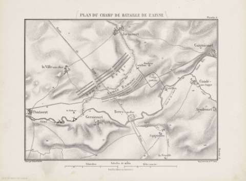
Title: Plan du Champ de Bataille de L'Aisne / gravé par Erhard Schièble
Author: Erhard Schièble, Georges, 1821-1880
Material or type of resouce Area: 1:40000
Publication: [París] : Henri Plon Éditeur, rue Garanciére 10, [188-?]
Physical description: 1 mapa ; 20 x 27 cm en h. de 27 x 37 cm
Content type: Imagen cartográfica
Media type: computadora
Carrier type: recurso en línea
Notes: Escala gráfica además en "Kilométres" y "Milles romains"
Relieve representado por normales y puntos acotados
Figura señalado el antiguo curso del río Aisne
Copia digital. España : Ministerio de Cultura y Deporte. Subdirección General de Coordinación Bibliotecaria, 2010
Other titles: En: [Histoire de Jules César] [atlas]. - [Paris : Henri Plon, Editeur, rue Garanciére 8, 10, 188-]. - Planche 8
Materia / lugar / evento: Batallas
Guerra
Estrategia
Imperio romano
Mapas militares
Aisne (Francia)
Picardía (Francia)
Francia
Related titles: AISNE (Francia) (Picardía). Batallas. 188-?. 1:40000 (S.I a.C)
UDC: 912:355.422]:[355.4:355.43](44 Aisne)'-0070/-0044'
37
44 Aisne
Type of publication:
Maps
Rights:
Préstamo:
Disponible
