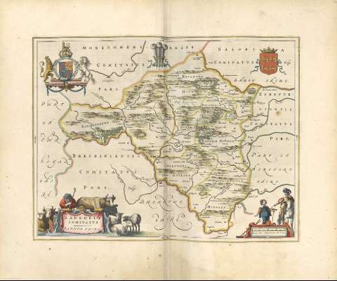
Radnoria Comitatus = Radnor shire


Section: Maps, plans and nautical charts
Uniform title: POWYS (Reino Unido) (Gales). Mapas generales. 1648. 1:120000
Title: Radnoria Comitatus = Radnor shire
Other titles: Radnor shire
Material or type of resouce Area: Escala [ca. 1:120000]
Physical description: 1 mapa : il. col. ; 38 x 50 cm
Content type: Imagen cartográfica
Media type: computadora
Carrier type: recurso en línea
Notes: Comprende la zona central del actual condado de Powys, de Knighton a Boughroud y del río Eland hasta Inglaterra
Toponimia abundante
Escala gráfica de 4 millas inglesas de las que cuatro hacen una alemana [= 6,1 cm]. Mención nominal de los puntos cardinales
Relieve por montes de perfil y sombreado
Diferencia con color las líneas divisorias entre los hundreds que forman el condado y sus límites, mencionando los colindantes
En el margen superior figuran los escudos de la casa real inglesa y de Gales, y en el centro un emblema que podría ser el del príncipe de Gales
Dos cartelas barrocas, una enmarcando el título, decorada con una escena costumbrista y otra con la escala, decorada con figuras típicas
Hidrografía
Arbolado
Núcleos de población destacando los más importantes, lugares y edificios más representativos
Todo el mapa está rodeado por una orla tipográfica a modo de marco
Orientado
Copia digital. Madrid : Ministerio de Cultura, 2010
Other titles: En: Nuevo Atlas del Reyno de Inglaterra. - Amsterdami : Apud Iohannem Blaeu, 1648. - [Mapa 37]
Materia / lugar / evento: Mapas generales
Divisiones administrativas
1648
Gales
Other authors: Blaeu, Joan, 1596-1673
UDC: 912(429.62) "1648"
(429.62 Radnor)
Type of publication:
 Maps
Maps
Préstamo:

 Disponible sólo para consulta en sala
