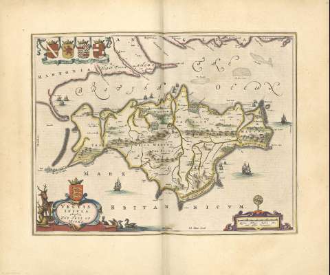
Vectis Insula : Anglice The isle of Wight


Section: Maps, plans and nautical charts
Uniform title: Wight (Gran Bretaña) (Isla). Mapas generales. 1648. 1:85.500
Title: Vectis Insula : Anglice The isle of Wight
Material or type of resouce Area: Escala [ca. 1:85.500]. 4 Milliaria Anglica [= 7,5 cm]
Physical description: 1 mapa : col. ; 57 x 64 cm
Content type: Imagen cartográfica
Media type: computadora
Carrier type: recurso en línea
Notes: Toponimia abundante
Núcleos de población, lugares y edificios más representativos
Relieve por montes de perfil y sombreado
Hidrografía
Mar de alrededor de las costas sombreado con un fino rayado
Arbolado
Mención nominal de los puntos cardinales
Título en cartela orlada con motivos animales y centrada con escudo coronado
Ilustrado con barcos de la época
En margen superior izquierdo figuran 4 escudos
Escala en cartela decorada con esfera armilar
Todo el mapa está rodeado por una orla tipográfica a modo de marco
Copia digital. Madrid : Ministerio de Cultura, 2010
Other titles: En: Nuevo Atlas del Reyno de Inglaterra. - Amsterdami : Apud Iohannem Blaeu, 1648. - [Mapa 10]
Materia / lugar / evento: Mapas generales
Núcleos de población
Montañas
Ríos
1662
Wight (Isla)
Gran Bretaña
UDC: (410.122)
Type of publication:
 Maps
Maps
