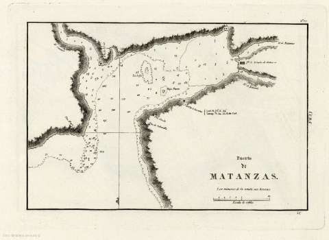
Puerto de Matanzas


 Disponible Holdings
 Section: Maps, plans and nautical charts
Title: Puerto de Matanzas
Author: España. Dirección de Hidrografía
Material or type of resouce Area: Escala [ca. 1:34.939], 10 cables [= 5,3 cm]
Publication: [Madrid] : Dirección de Hidrografía, [1809]
Physical description: 1 carta náutica ; 30 x 21 cm
Content type: Imagen cartográfica
Media type: computadora
Carrier type: recurso en línea
Notes: Presenta el puerto, la ubicación de la ciudad en su entrada, la desembocadura de varios ríos y otros accidentes geográficos de la ensenada
Coordenadas referidas al meridiano de Cádiz. Orientado con media lis
Relieve representado por sombreado y de perfil
Indica sondas batimétricas e isolíneas de batimetría
Señala que los números de la sonda son brazas y calidad del fondo marino
Copia digital . España : Ministerio de Cultura y Deporte. Subdirección General de Coordinación Bibliotecaria, 2010
Other titles: En: Portulano de la America Setentrional : dividido en quatro partes. - Madrid : Dirección de Hidrografía, 1809. - Parte tercera. Nº 29
Materia / lugar / evento: Cartas náuticas
Batimetría
Puertos
Matanzas
Related titles: Matanzas (Cuba) (Puerto). 1:34939
Type of publication:
 Maps
Maps
Rights:
