Colton's Holland and Belgium


 Maps, plans and nautical charts
Colton's Holland and Belgium (1872)
- Colton, G. Woolworth, 1827-1901
Maps, plans and nautical charts
Colton's Holland and Belgium (1872)
- Colton, G. Woolworth, 1827-1901
 Disponible Holdings
 Section: Maps, plans and nautical charts
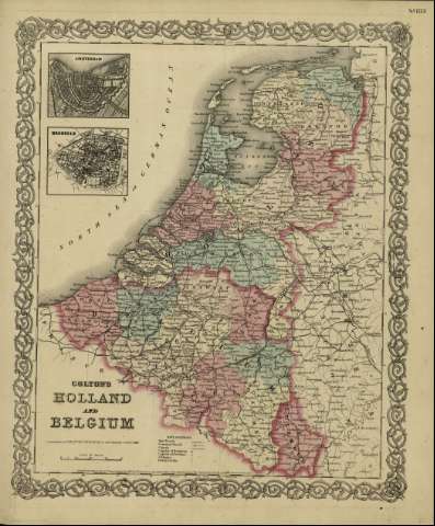
Title: Colton's Holland and Belgium / [drawn by George Woolworth Colton]
Author: Colton, G. Woolworth, 1827-1901
Material or type of resouce Area: Escala [ca. 1:1.481.480], 40 miles [= 5 cm] (E 2º05'--E 7º30' /N 53º30'--N 49º30')
Publication: New York : published by G.W. and C.B. Colton & Co., n 172 William St., [1872]
Physical description: 1 mapa : col. ; 44 x 36 cm
Content type: Imagen cartográfica
Media type: computadora
Carrier type: recurso en línea
Notes: Indica meridianos de origen: Washington y Greenwich ; Márgenes graduados.
Indica divisiones administrativas marcadas por colores.
Incluye clave de signos indicando red de carreteras, ferrocarriles, canales y ciudades.
Inserta: planos de población de "Amsterdam" y "Brusels".
Inserta nota: "Entered according to Act of Congress in the year 1855 by J.H. Colton & Co. in the Clerk's office of the district court for the southern district of New York".
Copia digital. España : Ministerio de Cultura y Deporte. Subdirección General de Coordinación Bibliotecaria, 2010
Materia / lugar / evento: Mapas políticos
Bélgica - Mapas
Holanda - Mapas
Europa Occidental - Mapas
Other authors: G.W. & C.B. Colton & Co
Related titles: Europa occidental. Mapas políticos. 1:1.481.480 (1872)
UDC: 912:[625.1+625.7](493-2/-5+492-2/-5)'1872'
493-2/-5
492-2/-5
Type of publication:
Maps
Rights:
