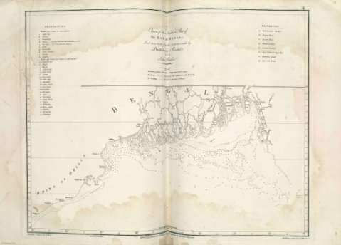
Chart of the Northern Part of The Bay of Bengal


 Maps, plans and nautical charts
Chart of the Northern Part of The Bay of Bengal
- Plaisted, Bartholomew, m. 1767
Maps, plans and nautical charts
Chart of the Northern Part of The Bay of Bengal
- Plaisted, Bartholomew, m. 1767
 Disponible Holdings
 Section: Maps, plans and nautical charts
Title: Chart of the Northern Part of The Bay of Bengal / Laid down chiefly from the Surveys made by Bartholomew Plaisted and John Ritchie ; Graduated & Engrav'd by B. Henry, Gravé par G. De-la-Haye, The Writing Engrav'd by W.Whitchurch
Author: Plaisted, Bartholomew, m. 1767
Material or type of resouce Area: Escala [ca. 1:1500000] (E 85°--E 93°/N 23°--N 19°)
Physical description: 1 mapa ; 46 x 60 cm
Content type: Imagen cartográfica
Media type: computadora
Carrier type: recurso en línea
Notes: Escala hallada a partir de un grado de latitud [= 7,4 cm]. Recuadro geográfico de 30' en 30'
Orografía de perfil
Indica sondas batimétricas, veriles y dirección de las corrientes
Toponimia costera de los principales accidentes geográficos y núcleos de población más significativos
Relación de las islas localizadas en las bocas del Ganges indicadas por clave alfabética
Consta una nota referente a los números de sonda y corrientes marinas
Copia digital. Madrid : Ministerio de Cultura, 2010
Other titles: En: Le Neptune Oriental. - [Lugar de publicación no identificado] : [Editor no identificado], [1802]. - [Mapa] 33
Materia / lugar / evento: Cartas náuticas
Golfos
1772
Bengala (Golfo)
Bangladesh
Bengala Occidental
Orissa
Other authors: Ritchie, John
Henry, B
Whitchurch, William
Delahaye, Guillaume-Nicolas, 1727-1802
Related titles: BENGALA (Golfo). N. Cartas náuticas. 1772. 1:1500000
UDC: 912:551.46](5-12:26.04-17)"1772"
5.12:26.04 Bengala-17
Type of publication:
Maps
Préstamo:
 Disponible sólo para consulta en sala
