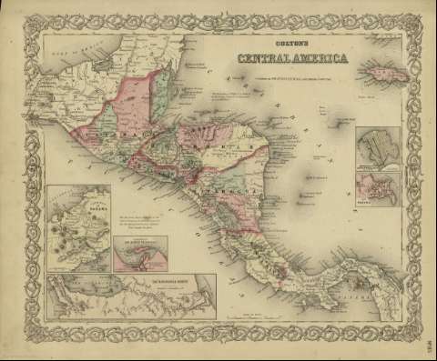
Colton's Central America


 Disponible Holdings
 Section: Maps, plans and nautical charts
Title: Colton's Central America / [drawn by George Woolworth Colton]
Author: Colton, G. Woolworth, 1827-1901
Material or type of resouce Area: [ca. 1:5.241.085], 150 miles [= 5,3 cm] (O 94º38'--O 76º37' /N 20º--N 07º)
Publication: [New York] : [published by S.W. and C.B. Colton & Co, n 172 William St.], [1872]
Physical description: 1 mapa : col. ; 36 x 44 cm
Content type: Imagen cartográfica
Media type: computadora
Carrier type: recurso en línea
Notes: Indica meridianos de origen: Washington y Greenwich ; Márgenes graduados.
Indica divisiones administrativas marcadas por colores.
Incluye clave de signos indicando red de carreteras, ferrocarriles, canales y ciudades.
Inserta: Isthmus of Panama ; Harbor of San Juan de Nicaragua ; The Nicaragua Route ; Manzanilla IIsland, Aspinwall City y Navy Bay ; City of Panama.
Inserta nota: "Entered according to Act of Congress in the year 1855 by J.H. Colton & Co. in the Clerk's office of the district court for the southern district of New York".
Copia digital. España : Ministerio de Cultura y Deporte. Subdirección General de Coordinación Bibliotecaria, 2010
The 'Nicaragua Route' -- City of Panama -- Harbor of San Juan de Nicaragua -- Isthmus of Panama -- Manzanilla Island, Aspinwall City y Navy Bay
Materia / lugar / evento: Mapas políticos
América Central - Mapas
Belice - Mapas
Guatemala - Mapas
Honduras - Mapas
El Salvador - Mapas
Nicaragua - Mapas
Costa Rica - Mapas
Other authors: G.W. & C.B. Colton & Co
Related titles: AMERICA CENTRAL. Mapas políticos. 1:5241085 (1872)
UDC: (728)
Type of publication:
 Maps
Maps
Rights:
