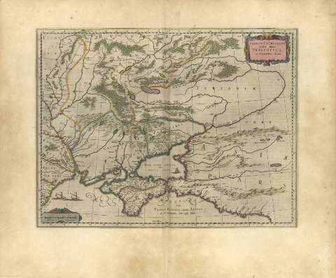
Taurica Chersonesus, Nostra aetate Przecopsca, et Gazara...


 Maps, plans and nautical charts
Taurica Chersonesus, Nostra aetate Przecopsca, et Gazara dicitur (1659)
Maps, plans and nautical charts
Taurica Chersonesus, Nostra aetate Przecopsca, et Gazara dicitur (1659)
Section: Maps, plans and nautical charts
Uniform title: Crimea (Península). Mapas generales. 1659
Title: Taurica Chersonesus, Nostra aetate Przecopsca, et Gazara dicitur
Material or type of resouce Area: Escala sin determinar
Publication, Production, Distribution, etc.: Producción: [Holanda], [1659]
Physical description: 1 mapa : col.
Content type: Imagen cartográfica
Media type: computadora
Carrier type: recurso en línea
Notes: Orientado
Escala de 25 Milliaria germanica
Relieve por montes de perfil y sombreado
Hidrografía
Divisiones administrativas diferenciadas por líneas de colores
Costas sombreadas con un fino rayado
Núcleos de población destacando los más importantes
Arbolado
Decorado con barcos de época
Toponimia abundante
Título y escala en cartelas barrocas
Márgenes graduados con mención nominal de los puntos cardinales
El mapa abarca la región al norte del Mar Negro, Crimea y las estepas del sur de Ucrania.
Copia digital. Madrid : Ministerio de Cultura, 2010
Other titles: En: Nuevo Atlas de las Partes Orientales de Europa. - En Amsterdam : A costa y en casa de Juan Blaeu, 1659. - [Lám. 19]
UDC: (477.7)
(560.6)
Type of publication:
Maps
Rights:
