De Custen van Bretaigne Waer in vertoont wort alle...


 Maps, plans and nautical charts
De Custen van Bretaigne Waer in vertoont wort alle gelentheyt tusschen Caap de Hague en t'Eylant Hyssant (1669)
Maps, plans and nautical charts
De Custen van Bretaigne Waer in vertoont wort alle gelentheyt tusschen Caap de Hague en t'Eylant Hyssant (1669)
 Disponible Holdings
 Section: Maps, plans and nautical charts
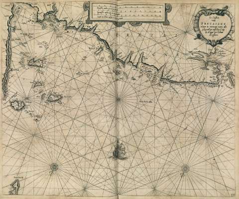
Title: De Custen van Bretaigne Waer in vertoont wort alle gelentheyt tusschen Caap de Hague en t'Eylant Hyssant
Material or type of resouce Area: Escala [ca. 1:617000]
Publication, Production, Distribution, etc.: Producción: [Holanda], [1669]
Physical description: 1 carta náutica : il., grab. ; 43 x 53 cm
Content type: Imagen cartográfica
Media type: computadora
Carrier type: recurso en línea
Notes: Escalas gráficas de 16 millas inglesas y francesas de 20 al grado [=14,4 cm], 14 millas españolas de 17 1/2 al grado [= 14,4 cm] y 12 millas holandesas de 15 al grado [= 14,4 cm]. Orientado con lis en rosa de treinta y dos vientos
Orientado con lis en rosa de rumbos
Orografía de perfil
Carta de araña en la que se indican sondas batimétricas, bancos de arena, fondeaderos, enfilaciones y toponimia costera
En el ángulo inferior derecho: "38"
Título enmarcado en cartela barroca
Decorado con la figura de un galeón
Copia digital. Madrid : Ministerio de Cultura, 2010
Other titles: En: Le Grand et Nouveau Miroir de la Mer. - [Amsterdam] : Pieter Goss, [1669]. - [Mapa 14]
Materia / lugar / evento: Cartas náuticas
UDC: 912:551.46(411.1/.5-17)"1669"
(411.1/.5-17)
Type of publication:
Maps
Rights:
Préstamo:
 Disponible sólo para consulta en sala
