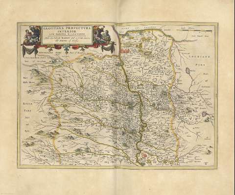
Glottiana praefectura inferior, cum baronia glascuensi =...


 Maps, plans and nautical charts
Glottiana praefectura inferior, cum baronia glascuensi = The Nether Warde of Clyds-Dail, and Baronie of Glasco (1654)
- Pont, Timothy, s. XVII
Maps, plans and nautical charts
Glottiana praefectura inferior, cum baronia glascuensi = The Nether Warde of Clyds-Dail, and Baronie of Glasco (1654)
- Pont, Timothy, s. XVII
 Disponible Holdings
 Section: Maps, plans and nautical charts
Title: Glottiana praefectura inferior, cum baronia glascuensi = The Nether Warde of Clyds-Dail, and Baronie of Glasco / Auct. Timoth. Pont
Author: Pont, Timothy, s. XVII
Other titles: The Nether Warde of Clyds-Dail, and Baronie of Glasco
Material or type of resouce Area: Escala [ca. 1:140000]
Publication, Production, Distribution, etc.: Producción: [Holanda], [1654]
Physical description: 1 mapa : col. ; 39 x 54 cm
Content type: Imagen cartográfica
Media type: computadora
Carrier type: recurso en línea
Notes: Comprende la zona oriental de la actual región de Strathclyde entre Glasgow y Lanark, y Tounhead y el lago Fisha
Escala gráfica de 6 millas, habiéndose tomado para su cálculo la milla escocesa [= 9,5 cm]. Mención nominal de los puntos cardinales en los márgenes
Límites de la provincia destacados con color
Título enmarcado en cartela barroca decorada con motivos costumbristas
Orientado
Relieve por montes de perfil y sombreado
Hidrografía
Arbolado
Ciudades representadas por conjuntos de edificaciones
Divisiones administrativas diferenciadas por líneas de colores
Márgenes graduados
Costas sombreadas con un fino rayado
Toponimia
Fecha de publicación tomada de la obra en la que se encuentra el mapa
Título en cartela decorada con escenas costumbristas
Copia digital. Madrid : Ministerio de Cultura, 2010
Other titles: En: Nuevo Atlas de los Reynos de Escocia e Yrlanda. - Amstelaedami : Apud Ioannem Blaeu, 1654. - [22]
Materia / lugar / evento: Strathclyde
Escocia
Gran Bretaña
UDC: 912(1-2/-5)(411)"1654"
(414.3 Clyde S.)
Type of publication:
Maps
Rights:
Préstamo:
 Disponible sólo para consulta en sala
