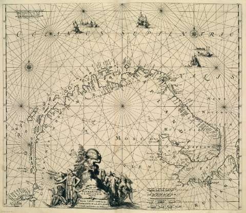
Finmarchiae et Laplandiae Maritima = Nieuwe Pafcaert...


 Maps, plans and nautical charts
Finmarchiae et Laplandiae Maritima = Nieuwe Pafcaert vande kuften Firnmarcken en Lapland Streckende van Drontem tot... (1715)
Maps, plans and nautical charts
Finmarchiae et Laplandiae Maritima = Nieuwe Pafcaert vande kuften Firnmarcken en Lapland Streckende van Drontem tot... (1715)
 Disponible Holdings
 Section: Maps, plans and nautical charts
Uniform title: Lappland (Finlandia). Mapas generales. 1715
Title: Finmarchiae et Laplandiae Maritima = Nieuwe Pafcaert vande kuften Firnmarcken en Lapland Streckende van Drontem tot Archangel
Other titles: Nieuwe Pafcaert vande kuften Firnmarcken en Lapland Streckende van Drontem tot Archangel
Material or type of resouce Area: Escala [ca. 6.516.774]. Geometrische of Duytsche Mylen van 15 in een Graad [= 6,82 cm]
Publication: [Amsterdam] : [Ex officina L. Renard], [1715]
Physical description: 1 carta náutica ; 51 x 59 cm
Content type: Imagen cartográfica
Media type: computadora
Carrier type: recurso en línea
Notes: Copia digital. Madrid : Ministerio de Cultura, 2010
Datos de edición tomados de la portada de la obra
Other titles: En: Atlas de la Navigation, et du Commerce qui se fait dans toutes les parties du Monde. - A Amsterdam : Chez Louis Renard, Marchand Libraire, 1715. - Lámina 6
Materia / lugar / evento: Laponia - Cartas náuticas
Regiones árticas - Cartas náuticas
Genre / form: Cartas náuticas
Other authors: Renard, Louis, 1648?-1746
Related titles: Finnmark (Noruega). Cartas naúticas. 1715
UDC: (481)
(480)
Type of publication:
Maps
Préstamo:
 Disponible sólo para consulta en sala
