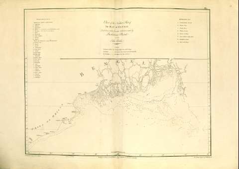
Chart of the Northern Part of the Bay of Bengal


 Maps, plans and nautical charts
Chart of the Northern Part of the Bay of Bengal (1772)
- Plaisted, Bartholomew, m. 1767
Maps, plans and nautical charts
Chart of the Northern Part of the Bay of Bengal (1772)
- Plaisted, Bartholomew, m. 1767
 Disponible Holdings
 Section: Maps, plans and nautical charts
Title: Chart of the Northern Part of the Bay of Bengal / Laid down chiefly from the surveys made by Bartholomew Plaisted and John Ritchie ; graduated & Engrav'd by B. Henry ; gravé par G. De-la-Haye ; The Writing Engrav'd by W. Whitchurch
Author: Plaisted, Bartholomew, m. 1767
Material or type of resouce Area: Escala [ca. 1:1501502] (E 85° -- E 93° / N 23° -- N 19°)
Publication: [London] : Publish'd.. by Alexander Dalrymple, 1772
Physical description: 1 carta náutica ; 46 x 60 cm
Content type: Imagen cartográfica
Media type: computadora
Carrier type: recurso en línea
Notes: Indica la sondas, bajos, veriles, corrientes
Comprende la parte más septentrional del golfo de Bengala
Título, autores principales e índices contenidos en un recuadro que ocupa la mitad superior del mapa
Escala hallada según la equivalencia en cm de un arco de meridiano de 7,4 cm
Graduado, la longitud según el meridiano de Greenwich
Clave toponímica para designar los ríos, islas, bancos y arrecifes
En el margen superior, nota explicando los símbolos empleados para señalar las corrientes marinas
Copia digital. Madrid : Ministerio de Cultura, 2010
Other authors: Ritchie, John
Whitchurch, William
Henry, B
Delahaye, Guillaume-Nicolas, 1727-1802
Related titles: Bengala (Golfo). Cartas náuticas. 1:1501502 (1772)
UDC: 540-11
Type of publication:
Maps
Préstamo:
 Disponible sólo para consulta en sala
