Six Early Printed Maps : selected from those exhibited...


 Maps, plans and nautical charts
Six Early Printed Maps : selected from those exhibited at the British Museum on the occasion of the International... (1928)
- British Museum
Maps, plans and nautical charts
Six Early Printed Maps : selected from those exhibited at the British Museum on the occasion of the International... (1928)
- British Museum
 Disponible Holdings
 Section: Maps, plans and nautical charts
Title: Six Early Printed Maps : selected from those exhibited at the British Museum on the occasion of the International Geographical Congress.
Author: British Museum
Material or type of resouce Area: Varias escalas
Publication: London : Printed by order of the Trustees, 1928 (University Press (Oxford)
Physical description: 1 atlas ([2] páginas, [10] hojas de láminas) : 6 mapas. ; 34 cm
Content type: Imagen cartográfica
Media type: computadora
Carrier type: recurso en línea
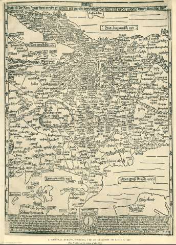
Notes: Incluye mapas de Europa central, las Islas Británicas, Mundo, la región del Atlántico norte, el territorio Mogul y el este de Estados Unidos.
Mapas datados 1492-1655
Tabla de contenidos en inglés, mapas en alemán y en latín
Copia digital. Madrid : Ministerio de Cultura, 2010
Contains: 1: Das ist der Rom-Weg von Meylen zu Meylen mit Puncten verzeychnet von eyner Stat zu der andern durch deutzsche Lantt / [by Erhard Etzlaub]. Nuremberg, ca. 1492 2: Britanniae insulae quae nunc Angliae et Scotiae regna continet cum Hibernia adiacente nova descriptio / [by George Lily]. Romae, 1546 3: Nova orbis terrarum descriptio optie proiecta / per Ioannem Blagravum. London, 1596 4: Nova Francia / [by Gabriel Tatton. London, ca. 1610 -- 5: A description of East India conteyninge th' Empire of the Great Mogoll / William Baffin deliniauit; Renold Elstrack sculp. London: T. Sterne, 1619 6: Novi Belgii novaeque Angliae nec non partis Virginiae tabula multis in locis emendata a N.J. Visschero. Amsterdam, ca. 1655.
Included records: A Description of East India Conteyning th' Empire of the Great Mogoll
Britanniae insulae quae nunc Angliae et Scotiae regna continet cum Hibernia adiacente nova descriptio
[...] Ver todos los registros incluidos (6)
Type of publication:
Maps
Rights:
Préstamo:
 Disponible sólo para consulta en sala
