Falmouth harbour-Cape Smallpoint-Arrowsick island


 Maps, plans and nautical charts
Falmouth harbour-Cape Smallpoint-Arrowsick island (1776)
- Des Barres, Joseph F. W (Joseph Frederick Wallet), 1722-1824
Maps, plans and nautical charts
Falmouth harbour-Cape Smallpoint-Arrowsick island (1776)
- Des Barres, Joseph F. W (Joseph Frederick Wallet), 1722-1824
 Disponible Holdings
 Section: Maps, plans and nautical charts
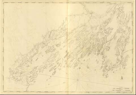
Title: Falmouth harbour-Cape Smallpoint-Arrowsick island / J.F.W. Des Barres ; [Tomkins Scripsir, H. Ashby Sculpsit]
Material or type of resouce Area: Escala [ca. 1:49000] (O 70°20'--O 69°43'/N 43°35'--N 43°16')
Publication: [London?] : J. F. W. Des Barres, 1776
Physical description: 1 mapa ; 74 x 105 cm
Content type: Imagen cartográfica
Media type: computadora
Carrier type: recurso en línea
Notes: Charts of the coast and harbors of New England, Nº 12
Título propio tomado del índice del volúmen
Graduado, longitud tomada respecto del meridiano de Greenwich
Constan dos escalas gráficas, una de cuatro millas legales, [=13,4 cm] de , y otra de cuatro millas naúticas, [= 15,2 cm]
Orientado con lis, indicando variación magnética
Incluye análisis batimetríco de la zona
Algunos terrenos aparecen divididos en pequeñas parcelas
Other authors: Ashby, Harry, 1744-1818
Tomkins, Thomas, 1743-1816
Related titles: Mericonig (Estados Unidos). Cartas náuticas (1776). 1:49000
UDC: 912:551.46]:627.22:551.42+322.22.155.64(741)"17"
741:26.04 Mericonig
Type of publication:
Maps
Préstamo:
 Disponible sólo para consulta en sala
