Leith Harbour, Prospect Harbuor, Bristal Bay, Shuldham...


 Maps, plans and nautical charts
Leith Harbour, Prospect Harbuor, Bristal Bay, Shuldham Harbor, Port Affleck, Sambro Harbour (1775)
- Des Barres, Joseph F. W (Joseph Frederick Wallet), 1722-1824
Maps, plans and nautical charts
Leith Harbour, Prospect Harbuor, Bristal Bay, Shuldham Harbor, Port Affleck, Sambro Harbour (1775)
- Des Barres, Joseph F. W (Joseph Frederick Wallet), 1722-1824
 Disponible Holdings
 Section: Maps, plans and nautical charts
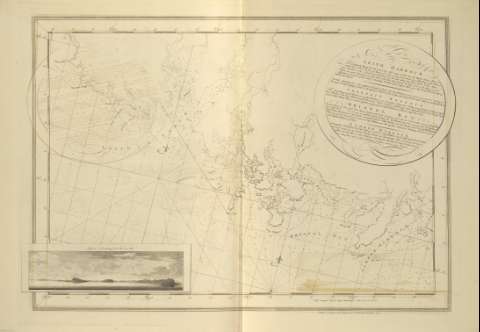
Title: Leith Harbour, Prospect Harbuor, Bristal Bay, Shuldham Harbor, Port Affleck, Sambro Harbour / J.F.W. Des Barres ; [Tomkins Scriptit, H. Ashby Scupit]
Material or type of resouce Area: Escala [ca. 1:28058] (O 63°53'--O 63°32'/N 44°38'-- N 44°26')
Publication: [London?] : J.F.W. Des Barres, 1775
Physical description: 1 mapa ; 67 x 95 cm
Content type: Imagen cartográfica
Media type: computadora
Carrier type: recurso en línea
Notes: The Sea Coast of Nova Scotia, Nº 19
Presenta la batimetría de sondas y veriles, calidad de arenas y fondeaderos de las bahías y puertos comprendidos en esta zona de la costa de Nueva Escocia
Orientado con dos nudos de 32 rumbos y lis; señalándose graficamente en ambos, el ángulo de declinación magnética
Graduado respecto al meridiano de Greenwich; siendo un minuto en latitud igual a 6,6 cm
El ángulo superior derecho recoge nota explicativa, enmarcada en cartela circular, de algunos de los puertos y bahías representados
El ángulo inferior izquierdo, por su parte recoge una perspectiva de costa de : "Hopson Nose; bearing N. N. W. two Miles"
Título propio tomado de la relación de los documentos que contiene el presente volumen, al comienzo del mismo
Other authors: Ashby, Harry, 1744-1818
Tomkins, Thomas, 1743-1816
Related titles: Leith Harbour (Canadá). Cartas náuticas. 1775. 1:28058
UDC: 912:551.468]:742:627.22:551.46(716)"1775"
716
Type of publication:
Maps
Préstamo:
 Disponible sólo para consulta en sala
