The South West coast of the Peninsula of Nova Scotia


 Maps, plans and nautical charts
The South West coast of the Peninsula of Nova Scotia (1776)
- Des Barres, Joseph F. W (Joseph Frederick Wallet), 1722-1824
Maps, plans and nautical charts
The South West coast of the Peninsula of Nova Scotia (1776)
- Des Barres, Joseph F. W (Joseph Frederick Wallet), 1722-1824
 Disponible Holdings
 Section: Maps, plans and nautical charts
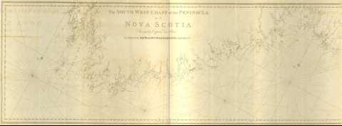
Title: The South West coast of the Peninsula of Nova Scotia / Surveyed by Captain Des Barres By Order of the Right Honorable the Lords commissioners of the Admiratly ; [Tomkins Scriptit, H. Ashby Sculpit]
Material or type of resouce Area: Escala [ca. 1:119400] (O 66°12'--O 63°12'/N 43°41'--42°58')
Publication: [London?] : J.F.W. Des Barres, 1776
Physical description: 1 mapa ; 72 x 206 cm, pleg. 80 x 58 cm
Content type: Imagen cartográfica
Media type: computadora
Carrier type: recurso en línea
Notes: The Sea Coast of Nova Scotia, Nº 9
Presenta la batimetría de sondas y veriles y calidad del fondo de la costa suroccidental de la península de Nueva Escocia, señalando al mismo tiempo, los principales accidentes geográficos de la misma
Graduado respecto al meridiano de Greenwich; siendo un grado de latitud igual a 1,55 cm
Orientado con cuatro nudos de 32 rumbos; dos de los cuales están coronados con lis, presentando además el ángulo de declinación magnética
Other titles: En: The Atlantic Neptune. - [London?] : J. F. W. Des Barres, 1774- 1780. - 9
Other authors: Ashby, Harry, 1744-1818
Tomkins, Thomas, 1743-1816
Related titles: NUEVA ESCOCIA (Canadá). Cartas náuticas. 1:119400 (1776)
UDC: 912:551.46]:551.42(716)"1776"
716
Type of publication:
Maps
Rights:
Préstamo:
 Disponible sólo para consulta en sala
