
 Biblioteca Virtual de Defensa
Plano Topografico del Ferro-Carril entre Trinidad y...


 Available Holdings
 Maps, plans and nautical charts
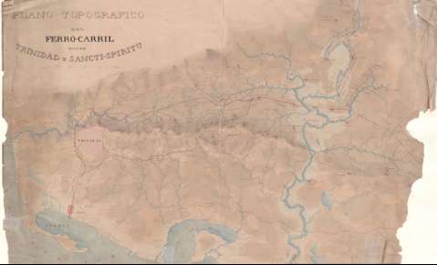
Plano Topografico del Ferro-Carril entre Trinidad y Sancti-Spiritu [sic] (1837-1900)
Maps, plans and nautical charts
Plano Topografico del Ferro-Carril entre Trinidad y Sancti-Spiritu [sic] (1837-1900)
Section: Maps, plans and nautical charts
Uniform title: Las Villas (Cuba). SO. Líneas ferroviarias. 1:40000 (1837-1900)
Title: Plano Topografico del Ferro-Carril entre Trinidad y Sancti-Spiritu [sic]
Other titles: Otro título: Plano topográfico del Ferrocarril entre Trinidad y Sancti Spíritus
Material or type of resouce Area: Escala [ca. 1:40000], 5000 Metros
Publication: [1837-1900]
Physical description: 1 mapa : ms., col. ; 47.0 x 76.6 cm
Content type: Imagen cartográfica
Media type: computadora
Carrier type: recurso en línea
Notes: Comprende la parte suroccidental de la provincia de Sancti Spiritus entre la ciudad del mismo nombre, Las Lajas, el río Manatí y el puerto y la población de CasildaOrientado con flechaRelieve por sombreadoFecha deducida a partir del contenido del documentoSeñala la línea de ferrocarril entre el puerto y la población de Casilda, Trinidad y Sancti SpiritusDibujado a varias tintas y lavado en varios colores
Subject / place /event: Líneas ferroviarias Mapas generales 1900 Trinidad (Cuba) - Mapas Sancti Spíritus (Provincia) - Mapas
Genre / form: Mapas generales
UDC: (729.1)
Type of publication:
Maps
Rights:
Loan:  No permitido
