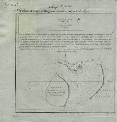
Plan of Musa Bay : latitude 19°1' N


 Disponible Holdings
 Section: Maps, plans and nautical charts
Uniform title: Fuga (Filipinas) (Isla). Cartas náuticas (1759). 1:18705
Title: Plan of Musa Bay : latitude 19°1' N / By Capt. George Baker August 1759 ; Engraved by B. Henry ; Writing by J. Russell
Edición: entre 1759 y 1774
Material or type of resouce Area: Scale [ca. 1:18.705]. 1 Nautic Milles [= 9,9 cm]
Publication: London : Published according to Act of Parliament by A. Darlrymple, Decr 1774
Physical description: 1 carta náutica : grab. ; ; 29 x 29 cm
Content type: Imagen cartográfica
Media type: computadora
Carrier type: recurso en línea
Notes: Orientado con media lis en cuadrante. Indica sondas batimétricas, bajos y fondeaderos
Indica números de sonda, fondeadero, calidad del fondo y veriles
Bajo el título amplia nota explicativa relativa a las caracteristicas del fondo de la bahía
Relieve representado por sombreado. Arbolado
Materia / lugar / evento: Cartas náuticas
Fondeaderos
Musa (Bahía)
Luzón (Isla)
Other authors: Baker, George Capt.
Dalrymple, Alexander
Henry, B
Russell, John, 1745-1806
UDC: 599.13 Fuga
Type of publication:
 Maps
Maps
Rights:
Préstamo:
Disponible
