Nieuwe en Naaukeurige Paskaart van het Eyland Hispaniola...


 Maps, plans and nautical charts
Nieuwe en Naaukeurige Paskaart van het Eyland Hispaniola of St. Domingo met alle desselss Havenen, Dieptens en... (1722?)
Maps, plans and nautical charts
Nieuwe en Naaukeurige Paskaart van het Eyland Hispaniola of St. Domingo met alle desselss Havenen, Dieptens en... (1722?)
 Disponible Holdings
 Section: Maps, plans and nautical charts
Uniform title: REPUBLICA DOMINICANA. Cartas náuticas (1722?). 1:300000
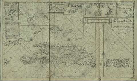
Title: Nieuwe en Naaukeurige Paskaart van het Eyland Hispaniola of St. Domingo met alle desselss Havenen, Dieptens en Ankergronden, als meede de door passeeringe tusschen de Caiques en andere Eylanden / naer de Opservatien van Monsr. Frezier = Nouvelle Carte de L'Isle de Hispaiola ou St. Domingue et Debouquemens Circonvoisins / Dressée suivant les observations de Monsr. Frezier
Material or type of resouce Area: Escala [ca. 1:1.300.000] ; [proyec. Mercator], 40 Franches en Engelsche Mylen van 20 in een Graad [= 16,2 cm]
Publication: Tot Amsterdam : by Ioannes van Keulen, Boek en Zer-Kaart verkooper aan de Nieuwen Brug, [1722?]
Physical description: 1 carta náutica : montado sobre tela ; 59 x 101 cm
Content type: Imagen cartográfica
Media type: computadora
Carrier type: recurso en línea
Notes: Comprende desde Long Island hasta Puerto Rico
Dedicatoria: "Aan de Heer Hendrik Lynslager Capt. ter Zee in dienst van / edelmogende Colegie ter Admiraliieyt id. Amsterdam werd dese Caart opgedraegen door syn Onderdanige dienr. Joannes van Keulen"
Escala gráfica de 35 millas españolas de 171 al grado [= 16,2 cm]. Coordenadas referidas al meridiano de París (O 78°10'-O 66°00'/N 23°55'-16°50'). Orientado con 3 rosas de 16 vientos prolongados y lis
Relieve de perfil
Indica fondeaderos y sondas batimétricas
Fecha de publicación tomada del: "Tooley's Dictionary of Mapmakers", p. 226
Señala poblaciones, ríos, cayos, arrecifes, derrotas y toponimia costera
Dedicatoria enmarcada en cartela decorada con motivos marinos, escudos, esferas, etc. y las escalas gráficas en filacteria
Inserta: "De Stad St. Domingo met een gedeelte van't omteggende Land". Escala [ca. 1:20000] ; "De Noord Kust van't Eyland Hispaniola" ; "De Noord Kust van het Eyland Hispaniola" ; "De Zuyd Kust van het Eyland Hispaniola" ; "De Rivier Macouri, aan de Zuyd Kust van het Eyland Hispaniola" ; "De west Kust van het Eyland Hispaniola"
Materia / lugar / evento: Cartas náuticas
Haití
Puerto Rico
Other authors: Frézier, Amédée François, 1682-1773
Keulen, Johannes van, 1654-1715
UDC: 729.3
Type of publication:
Maps
Rights:
Préstamo:
Disponible
