Bowles's New Pocket Map of Jamaica : Divided into it's...


 Maps, plans and nautical charts
Bowles's New Pocket Map of Jamaica : Divided into it's Parishes and C. (1792?)
Maps, plans and nautical charts
Bowles's New Pocket Map of Jamaica : Divided into it's Parishes and C. (1792?)
 Disponible Holdings
 Section: Maps, plans and nautical charts
Uniform title: JAMAICA. Mapas generales (17). 1:638569
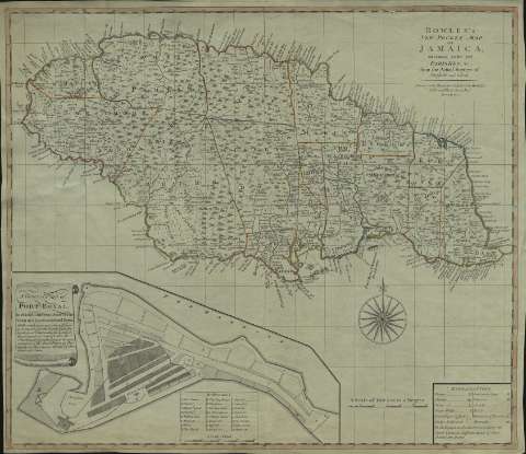
Title: Bowles's New Pocket Map of Jamaica : Divided into it's Parishes and C. / from the Actual Surveys of Sheffield and others
Material or type of resouce Area: Scale [ca. 1:638.569]. 30 miles 60 to a degree [= 8,7 cm]
Publication: London : Carington Bowles, Nº 69 in St. Pauls Church Yant, [1792?]
Physical description: 1 mapa : col. ; 47 x 55 cm
Content type: Imagen cartográfica
Media type: computadora
Carrier type: recurso en línea
Notes: Longitud del meridiano de Londres
Márgenes graduados. Orientado con lis en rosa de 16 vientos
Relieve representado por montes de perfil. Costas sombreadas con un fino rayado. Hidrografía. Caminos. Divisiones administrativas diferenciadas por líneas de color. Vegetación representada de forma esquemática
Indica veriles, bajos, fondeaderos y sondas batimétricas
Tabla de signos convencionales para indicar núcleos de población de distinta categoría, caminos, etc.
Inserta, con título en filacteria: "A General Plan of Port Royal". - Escala [ca. 1:3.200]. 800 pies [= 7,7 cm]. Con clave alfanumérica referenciando los puntos de mayor interés
Materia / lugar / evento: Mapas generales
Planos de población
Divisiones administrativas
Port Royal (Jamaica)
Jamaica
Other authors: Sheffield
Bowles, Carrington, 1724-1793
UDC: 729.2
Type of publication:
Maps
Rights:
Préstamo:
Disponible
